- Trump approves federal assistance amid Arkansas flooding
- Weather Impact Alert: Tornado Watch issued for much of Southeast Texas until 9 p.m.
- Colorado State University predicts above-average 2025 Atlantic Hurricane Season
- South and Midwest face potentially catastrophic rains and floods while reeling from tornadoes
- Deadly 2024 hurricanes prompt WMO to retire three names
Strong storms will bring heavy rain, flooding threat to Carolinas Tuesday

The Carolinas will see heavy rain with the threat of flash flooding Tuesday as a storm system moves over the region. Damaging winds and tornadoes are also possible.
CHARLOTTE, N.C. — The Carolinas will have two chances for severe weather this week, starting with a storm system that will bring heavy rain to the Charlotte region Tuesday afternoon.
Forecaster Larry Sprinkle said Charlotte will be at risk for heavy rain from around 2 p.m. through Tuesday evening with more storms Wednesday night into Thursday.
“At 5 p.m. Tuesday afternoon, there is going to be heavy rain from Charlotte all the way down to Columbia, South Carolina,” Sprinkle said.
A line of strong storms extends all the way from North Carolina to the panhandle of Florida with severe weather possible in most areas along that front Tuesday. This includes the entire Charlotte metro, with heavy rain and flooding possible, starting around 4 p.m.
“A band of strong and severe storms from the upstate of South Carolina down into Georgia will bring heavy rain to Charlotte, Rock Hill, Chester, Lancaster, all the way to Hickory,” Sprinkle said. “Be prepared for your afternoon commute. Give yourself some extra time. From around 4 to 6 we’re talking about some very heavy flooding rains and flash floods, as well.
The next weather system will move over the Carolinas Wednesday night into Thursday. Sprinkle said we’ll see heavy rain and the potential for strong thunderstorms overnight into Thursday morning.
This system will bring even more rain, as well as the potential for flooding, damaging winds and isolated spin-up tornadoes.
The tornado threat is at 2% on Tuesday afternoon. Mainly a spin-up tornado will be possible but these storms will be flying. This means that isolated winds up to 40-60+ mph will be possible along the line. Rain rates will also be high, which means localized and urban flooding will be possible quickly.
The Top 3 in order
- Flooding
- Wind Damage
- Tornadoes
The timing
Tuesday afternoon will see a fast-moving line of storms sweeping across the Carolinas.
As mentioned, the mid-to-late afternoon will be the primary window for severe weather. This should be a quick-moving line of storms that could create gusty winds and a spin-up tornado. Any damage will happen quickly along the leading edge.
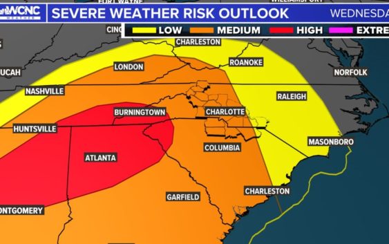
Round 2: Wednesday evening into Thursday morning
This is trending to be an overnight event. Areas in the red again represent a 10% chance for tornadoes. This will likely be a QLCS (Quasi-Linear Convective System). This means a strong line of thunderstorms that is not completely straight. This allows for spin-up tornadoes to form. This setup happened last Thursday that caused a tornado in Anson into Stanly County.
This means a threat of damaging winds overnight but also a tornado risk in the dark. Storm fuel will wane overnight, so the later the timing, the better. The exact timing is still unclear, but anytime in the evening and beyond you need to be “weather aware.”