- NC's FEMA aid extension for Hurricane Helene recovery denied
- NC's FEMA aid extension for Hurricane Helene recovery denied
- NC Gov. Stein pledges continued Hurricane Helene recovery support in 100-day address
- Austin adopts new map that greatly expands area at risk of wildfire
- CenterPoint Energy accelerates infrastructure improvements ahead of hurricane season
Widespread rain expected Tuesday, severe weather possible Wednesday night: Panovich

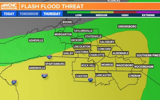
The Carolinas will see heavy rain with the threat of flash flooding Tuesday as a storm system moves over the region. Damaging winds and tornadoes are also possible.
CHARLOTTE, N.C. — The Carolinas will have two chances for severe weather this week, starting with a storm system that will bring heavy rain to the Charlotte region Tuesday afternoon.
Chief Meteorologist Brad Panovich said a large mass of showers and thunderstorms will move into the Carolinas from the southwest Tuesday afternoon with heavy rain and storms expected from around 3 p.m. until 7 p.m. The good news, at least for most of the Carolinas, is the tornado risk is low during Tuesday’s storms.
“The severe weather risk has primarily been for the southern sections of this front,” Panovich said. “I would expect that to continue off to the east, the northern part is just going to be heavy rain, and that’s primarily what I would expect for our region.”
The line of storms extends all the way from North Carolina to the panhandle of Florida with severe weather more likely in areas south of the Charlotte metro. Some South Carolina schools in the Columbia area will dismiss students early Tuesday due to the threat of tornadoes and storms.
Tuesday timing
Panovich said he expects rain to move into the Carolinas by lunchtime. By 3 p.m., Charlotte will most likely start seeing showers and storms.
“By 5 o’clock, we’re going to have heavy rain over us,” Panovich said. “Then we go to 6, and 7, notice in the Midlands of South Carolina, there could be some waves of heavy rain that push off to the east.”
Round 2: Late Wednesday into Thursday
Panovich said the second wave of storms, which will roll into the Charlotte area late Wednesday night, could produce severe weather. There won’t be as much rain during the second system, but it will make up for it with severe potential.
“Even though tomorrow’s event may not be as widespread as the rain we’re seeing today, it certainly has the potential to produce more severe weather,” Panovich said. “We’re also going to have the risk for possibly some heavy rain, some flash flooding.”
Panovich said there’s a higher risk of severe storms but not as many showers across the region with Wednesday night’s setup.
“It’s kind of deceiving,” Panovich said. “It’s one of those things where the chance of rain on Wednesday and Thursday might be 40%, but maybe half of those could be severe. Whereas today (Tuesday), the chance of rain is like 90% and maybe just 5% of those could be severe.
Panovich said he’s hopeful that by the time those storms reach Charlotte, they’ll have weakened significantly.
“Hopefully it’s weakened by then, but honestly everyone’s focus will be on what’s going on in the mountains,” Panovich said. “This stuff, you’ve got to watch out here. It doesn’t look real impressive, but one or two of these cells are going to be all by themselves and they’re going to be able to tap into this warm, humid air coming from the west. There’s some potential there could be a couple of really nasty storms.”