- NC's FEMA aid extension for Hurricane Helene recovery denied
- NC's FEMA aid extension for Hurricane Helene recovery denied
- NC Gov. Stein pledges continued Hurricane Helene recovery support in 100-day address
- Austin adopts new map that greatly expands area at risk of wildfire
- CenterPoint Energy accelerates infrastructure improvements ahead of hurricane season
Researchers at Colorado State University call for an above-average hurricane season

For the seventh year in a row, a very active hurricane season is expected in the Atlantic Basin.
FORT COLLINS, Colo. — Researchers are predicting another active hurricane season.
On Thursday, the well-respected team at Colorado State University’s Tropical Weather and Climate Research Division, led by Dr. Philip Klotzbach, released their outlook for the 2022 hurricane season.
The lack of El Niño in the Pacific Ocean, and warmer than normal Atlantic water temperatures, are again expected to heavily contribute to the tropical outlook.
This outlook is separate from the forthcoming outlook produced by NOAA’s National Hurricane Center in Miami. Last year, the tropical division of the National Weather Service issued its outlook in May.
There has been some debate on whether or not the Atlantic Ocean basin is actually experiencing “above-average” hurricane seasons — or whether new technologies, including enhanced weather satellites, is making it easier to observe storms that previously could have gone undetected.
When researchers, including those at Colorado State University, determine a season to be more or less than the average, that prediction compares to cumulative averages observed between 1991 – 2020, which is well after the launch of the first weather satellites.
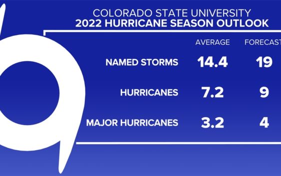
The 2022 forecast calls for nineteen named storms (tropical storm or stronger) with nine of them reaching hurricane status. Of those nine, four are forecast to become a major hurricane.
The average numbers from the past 30 years showed 14.4 named storms, 7.2 hurricanes, and 3.2 major hurricanes.
Why do they study tropical weather at Colorado State University?
This unit at Colorado State University (CSU) was founded by Dr. William Gray, who led the program for decades. They put out the first seasonal forecast in 1984 and since then, it has evolved into a trusted source for tropical weather forecasts and updates.
According to Colorado State University’s website, Gray spent over 60 years in meteorology and made “vast contributions in the field of tropical cyclone research.”
In response to the question about why they study hurricanes in Colorado, he once said, “Storm surge can’t get you at 5,000 feet!”
What do the forecasters look at?
While a lot of work goes into making these forecasts, the main thing the researchers do is look at climate patterns. Gray was able to associate differing tropical activity with these trends, such as the El Niño Southern Oscillation.
Other than climate patterns, Dr. Klotzbach and his current team review decades of historical data, including data on sea surface temperatures, wind shear, and sea-level pressure.
And like all good forecasters, they will make adjustments based on their personal experience and what they’ve noticed from these patterns and trends. We say this a lot in meteorology, but experience is often one of the most important forecast tools.
Why does a lack of El Niño result in more storms?
A lack of El Niño normally results in a La Niña pattern or neutral pattern. This often means less wind shear, weaker trade winds, and less atmospheric stability.
While shear is often a factor working towards tornado development, shear is a factor that discourages the development of tropical storms or hurricanes. High wind shear and trade wind activity rip storms apart to the point where they either diminish completely or weaken. With lower wind shear values, a storm has a clear path to strengthen as it feeds off the warm ocean waters in the Atlantic.
These conditions are expected to be active in the 2022 hurricane season.
Last, but certainly not least, an unstable atmosphere will always lead to more storms.
How often are seasons above average?
It differs year-to-year. In the last decade, there have been more above-average seasons than below-average.
2013, 2014, and 2015 were all below average, but that three-year streak ended in 2016. Since then, every year has experienced an above-average hurricane season.
This is another example of why adjusting the 30-year average is important.
The hurricane season officially runs between June 1 and November 30, but storms are still possible outside those months.
Do hurricanes and tropical storms impact Charlotte?
In North Carolina and South Carolina, the biggest impact from hurricanes or tropical storms is often rain. Persistent rain, which can last for days, creates a risk of flash flooding.
An example of this flood threat was seen during the historic and deadly flooding in Alexander County on November 12, 2020. Unfortunately, six people lost their lives in the flash flooding caused by the remnants of Tropical Storm Eta.
In 2018, Hurricane Florence made landfall near Wrightsville Beach, North Carolina, but was a tropical depression by the time it reached Charlotte. The storm battered the city and surrounding areas for days. It left greenways, backyards, and roads flooded. The relatively “weak” winds of 35 mph still managed to down trees, leaving tens of thousands of people without power.
But one historic storm still remains in the minds of Carolinas’ longest residents.
On September 11, 1989, Hurricane Hugo made landfall as a Category 4 hurricane near Charleston, South Carolina. It maintained hurricane strength even as it arrived in Charlotte with wind gusts near 90 mph.
The storm smashed windows in many of Uptown Charlotte’s skyscrapers and even destroyed some buildings.
Folks in Charlotte and surrounding areas lost power for days. Some were without power for weeks. In the Carolinas, Hugo caused billions of dollars in damage and claimed the lives of 37 people.