- How photos lost in disasters like Hurricane Helene find their way home, with a little help from people who care
- Dangerous travel conditions, ice/snow and flooding possible in the mountains Tuesday and Wednesday
- Weather Impact Alert: Dangerous travel conditions, ice/snow and flooding possible in the mountains Tuesday and Wednesday
- North Carolinians perplexed by unexpected DMV refunds tied to Hurricane Helene relief
- Yes, NCDOT is sending Hurricane Helene relief checks
Strong storms push into central North Carolina bringing heavy rain, wind, possible tornados
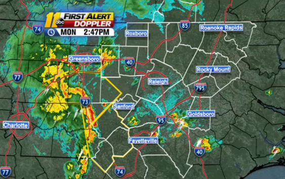
RALEIGH, N.C. (WTVD) — A strong line of storms pushing east into central North Carolina are causing severe weather alerts to pop up around the region.
Click here to view the latest weather alerts.
A tornado warning was issued just before 3 p.m. for parts of Chatham, Lee and Moore counties. That warning lasts until 3:30 p.m.
LIVE RADAR
This line of storms is associated with a cold front moving into the area. This will bring widespread showers and storms throughout Monday evening.
Some of the storms could be severe with damaging wind gusts, small hail or even an isolated tornado.
Road ponding and isolated street flooding could happen in some areas. Rain totals will likely be around 1-2 inches in most places, but some areas could see as much as 3 inches.
Copyright © 2022 WTVD-TV. All Rights Reserved.