- Artists transform hurricane aftermath into hoop-inspired masterpieces at Charlotte exhibit
- NC's cost for Hurricane Helene damage is nearly $60 billion, state says
- State to develop drone program to better respond to disasters like Helene, Florence
- South Carolina residents face deadline to get storm debris out to the curb after Hurricane Helene
- SCDOT to pick up Hurricane Helene debris for a final day in South Carolina
Monday Tornado near Reedy Creek, Harrisburg was EF-1 strength

The National Weather Service toured storm damage Tuesday in portions of Mecklenburg and Cabarrus counties Tuesday.
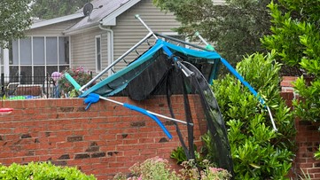
CHARLOTTE, N.C. — Preliminary data from the National Weather Service has found storm damage near the Reedy Creek neighborhood in Charlotte and Harrisburg in Cabarrus County came from a tornado that was at least an EF-1 in strength.
The tornado touched down during Monday’s severe weather outbreak in the Carolinas.
National Weather Service crews surveyed the damage in Mecklenburg and Cabarrus counties Tuesday morning.
The preliminary investigation findings from the National Weather Service found the tornado likely began near Plott Road before moving over the Burnt Umber Drive neighborhood. In this location, investigators found damage to hardwood trees consistent with an EF-1 tornado with winds of approximately 90 mph.
Roof damage was reported to homes along Hood Road and Rocky River Road.
The tornado was on the ground for 10 miles as it moved north and east into Cabarrus County, where damage was reported in the Camelot neighborhood.
The tornado lifted near Rocky River Elementary School.
Meteorologist KJ Jacobs followed Tuesday’s survey as crews examined damage in Mecklenburg County.
Ahead of the tornado warning Monday, Panovich and WCNC Charlotte meteorologist Chris Mulcahy were tracking the storm live on WCNC Charlotte’s YouTube channel. They were monitoring the rotation ahead of the official warning.
Thousands of people lost electricity during Monday’s storms, which took down trees and power lines near Harrisburg. The second round of storms brought damaging winds and a possible tornado to northern Stanly County Monday evening.
Chief Meteorologist Brad Panovich said there are three likely tornado tracks in the Carolinas, including Chesnee, South Carolina.
Neighbors described the sights and sounds they witnessed.
“She said it sounded like a train coming straight through the backyard,” Virginia Luther said.
Panovich said a possible tornado began around 1:40 p.m. before moving northeast across Interstate 485.
WCNC Charlotte viewers shared their photos of the damage with Brad Panovich on the WCNC app and social media. Here’s how you can share your storm damage photos with us.
Storm damage across the Charlotte area | Viewer photos

Wake Up Charlotte To Go is a daily news and weather podcast you can listen to so you can start your day with the team at Wake Up Charlotte.
SUBSCRIBE: Apple Podcasts || Spotify || Stitcher || TuneIn || Google Podcasts
All of WCNC Charlotte’s podcasts are free and available for both streaming and download. You can listen now on Android, iPhone, Amazon, and other internet-connected devices. Join us from North Carolina, South Carolina, or on the go anywhere.