- David & Nicole Tepper increase Hurricane Helene relief commitment to $750k
- David & Nicole Tepper increase Hurricane Helene relief commitment to $750k
- McDowell County wildfire spreads to 500 acres, evacuation orders in place
- Evacuations in Caldwell County due to wildfire
- Northwest Houston 'ghost neighborhood' caused by repeated flooding to become latest detention basin
Tropical Storm Colin hovers along the coast
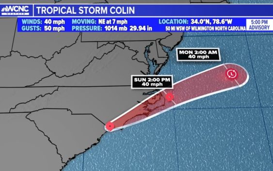
The tropical storm formed roughly 50 miles southwest of Myrtle Beach, South Carolina with maximum sustained winds of 40 mph.
CHARLOTTE, N.C. — Colin continues to move northeast at about 7 mph. Dangerous beach conditions, elevated rip currents, and isolated flooding remain the primary concerns. Improvements are expected as early as tomorrow.
Beachgoers should expect on and off showers with pockets of rain – heavy at times and gusty winds on occasion. Watch for swim advisories if you have plans to visit the beaches over the holiday weekend. The primary impacts are rough surfs with elevated rip currents.
The tropical storm formed around 5 a.m. Saturday roughly 50 miles southwest of Myrtle Beach, South Carolina with maximum sustained winds of 40 mph.
A Tropical Storm Warning is in effect for coast of North Carolina covering the entire Outer Banks.
Colin will continue to produce heavy rainfall across portions of coastal South and North Carolina through Sunday morning.
An additional one to two inches of rainfall, with isolated amounts up to four inches, is anticipated in the area.
The center of Colin is expected to move northeastward and just inland of North Carolina coasts through Sunday, and then move out westward in the Atlantic Ocean late Sunday. The center of circulation is not well-defined. The heaviest rain and strongest wind field is confined to the center of circulation and primarily offshore.