Colin downgraded from Tropical Storm status
It formed roughly 50 miles southwest of Myrtle Beach, South Carolina with maximum sustained winds of 40 mph.
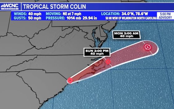
CHARLOTTE, N.C. — Colin is now downgraded to a tropical depression, losing its status as a tropical storm from earlier in the day Saturday.
The storm moved northeast along the East Coast at about 7 mph. Dangerous beach conditions, elevated rip currents, and isolated flooding were the primary concerns. Improvements are expected as early as tomorrow.
Beachgoers were advised to expect on and off showers with pockets of rain – heavy at times and gusty winds on occasion. It’s still advised to heed any swim advisories if you have plans to visit the beaches over the holiday weekend. The primary impacts are rough surfs with elevated rip currents.
The tropical storm formed around 5 a.m. Saturday roughly 50 miles southwest of Myrtle Beach, South Carolina with maximum sustained winds of 40 mph. Around 10:30 p.m., it was downgraded.
A Tropical Storm Warning was in effect for coast of North Carolina covering the entire Outer Banks.
The tropical depression will continue to produce heavy rainfall across portions of coastal South and North Carolina through Sunday morning.
An additional one to two inches of rainfall, with isolated amounts up to four inches, is anticipated in the area.
The center of the depression is expected to move northeastward and just inland of North Carolina coasts through Sunday, and then move out in the Atlantic Ocean late Sunday. The center of circulation is not well-defined. The heaviest rain and strongest wind field is confined to the center of circulation and primarily offshore.

