- Artists transform hurricane aftermath into hoop-inspired masterpieces at Charlotte exhibit
- NC's cost for Hurricane Helene damage is nearly $60 billion, state says
- State to develop drone program to better respond to disasters like Helene, Florence
- South Carolina residents face deadline to get storm debris out to the curb after Hurricane Helene
- SCDOT to pick up Hurricane Helene debris for a final day in South Carolina
Street flooding, damaging winds possible for Houston area Thursday | Timeline

Torrential rain and one or two gusty thunderstorms are possible as a cold front approaches the area Thursday.
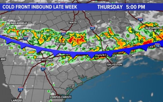
HOUSTON — You’re going to want to pay attention to the forecast over the next several days as a front is expected to push a line of strong thunderstorms through the Houston area tomorrow.
The cold front’s interaction with the hot and humid air mass in place will produce widespread storms and downpours, potentially with gusty winds. Rainfall totals may be grand in some locations, topping a few inches as the front rolls through and then stalls to our south.
Timeline of Thursday thunderstorms
THURSDAY MORNING: Most areas start dry… a few showers can’t be ruled out north of I-10.
12PM: Showers and thunderstorms will be developing along the boundary in our northern cities and counties at this time.
2PM: The line of thunderstorms will slide farther south potentially reaching northern Harris county at this point.
4PM: The line of thunderstorms continues to push south, reaching the I-10 corridor.
6PM: The line pushes south of I-10… steady rain still falling along the I-10 corridor.
9PM: Most storms push offshore, showers linger.
The line of storms could produce up to 3 inches of rain in some areas, which could lead to street flooding. In addition to the rain, expect lots of lightning.
Strong to severe storms are possible as the line arrives, similar to what we saw last week.
Wind gusts could reach 40 to 50 mph in spots.
It’s not a strong setup for tornadoes. However, an isolated tornado is not out of the question
Follow the KHOU 11 Weather Team for daily updates: