- Fake job seekers are flooding the market, thanks to AI
- One set of evacuation orders lifted in Caldwell County after wildfire contained
- 'We gutted every building' | Chimney Rock rebuilding after Hurricane Helene
- 'We gutted every building' | Chimney Rock rebuilding after Hurricane Helene
- Debris from Hurricane Helene provides fuel, complicates containment for spring wildfires
Ian downgraded to tropical storm, set to drench North Carolina on Friday

RALEIGH, N.C. (WTVD) — Following a full day of battering Florida, Ian has been downgraded to a tropical storm.
As of Thursday morning, the center of Tropical Storm Ian was located south of Daytona Beach. Sustained winds were clocked at 65 miles per hour and the system was moving northeast at 8 miles per hour.
Ian will head back into open water in the Atlantic Ocean later Thursday, where it could regain some strength before turning back to land and striking the United States again. This upcoming landfall is projected to happen somewhere between Savannah, Georgia, and Charleston, South Carolina on Friday.
Friday the storm should begin to pick up some speed too. This will help push the storm through North Carolina quicker than it has moved through Florida.
Timeline
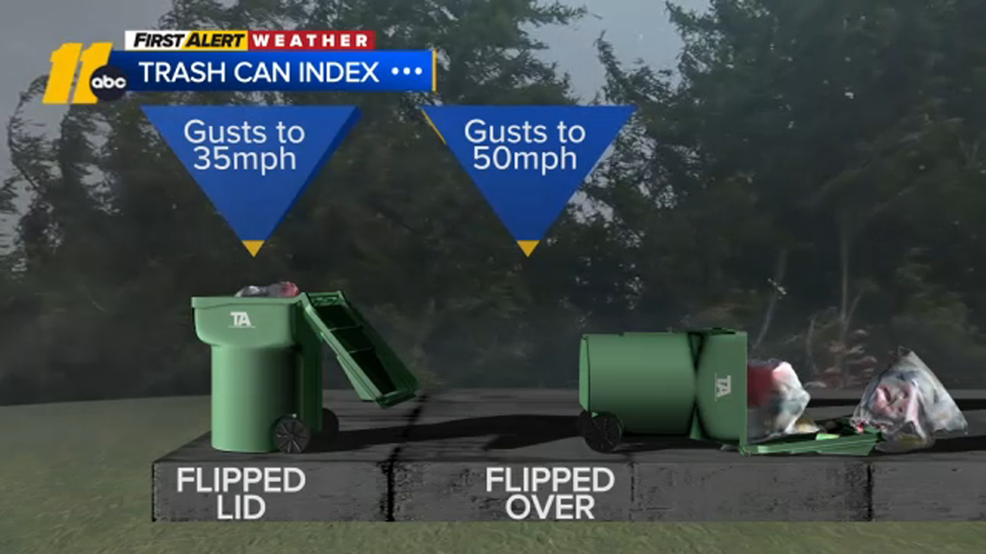
Wind gusts will begin to pick up in North Carolina on Thursday. Gusts could be around 20 miles per hour, which means people should go ahead and secure loose items outside.
The rain will not begin until late Thursday or early Friday morning.
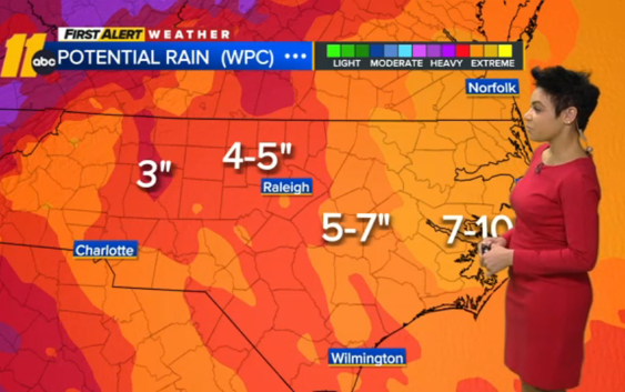
Friday will be a complete washout with pretty much all of North Carolina seeing heavy rainfall during an approximately 18-hour window.
In central North Carolina, heavy rain will likely begin before the morning commute and last into the evening hours. However, by late Friday evening the majority of the rain will be over.
Saturday will include some scattered showers, especially in the morning.
What to expect
ABC11 Meteorologist Kweilyn Murphy said central North Carolina can expect anywhere from 3-7 inches of rain from Ian.
Flooding will not be widespread, but localized flooding is possible in areas that see heavy downpours.
There is also an isolated tornado risk — mainly south and east of the Triangle.
Big Weather’s hurricane emergency kit
Wind gusts could get up to 40 miles per hour at times. That is strong enough to lift and move some unsecured items.

Tropical Storm Warnings are also in effect along the North Carolina coast from the South Carolina border up past Morehead City. No storm surge warnings are yet in effect in North Carolina.
North Carolina prepares for Ian
Gov. Roy Cooper declared a State of Emergency on Wednesday ahead of the arrival of the remnants of Hurricane Ian.
Cooper is scheduled to give an update on preparations at 3 p.m. ABC11 will broadcast that update live on television and in all of our apps.
North Carolina’s price gouging law against overcharging in a state of emergency is also in effect statewide.
Cooper also authorized the activation of about 80 members of the North Carolina National Guard to assist as needed.
Destruction in Florida
Hurricane Ian left a path of destruction in southwest Florida, trapping people in flooded homes, damaging the roof of a hospital intensive care unit and knocking out power to 2 million people before aiming for the Atlantic Coast.
One of the strongest hurricanes to ever hit the United States barreled across the Florida peninsula overnight Wednesday, threatening catastrophic flooding inland, the National Hurricane Center warned.
The center’ said Ian became a tropical storm over land early Thursday and was expected to emerge over Atlantic waters near the Kennedy Space Center later in the day. Flooding rains continued across the state, and a stretch of the Gulf Coast remained inundated by ocean water, pushed ashore by the massive storm.
“Severe and life-threatening storm surge inundation of 8 to 10 feet above ground level along with destructive waves is ongoing along the southwest Florida coastline from Englewood to Bonita Beach, including Charlotte Harbor,” the center said.
In Port Charlotte, along Florida’s Gulf Coast, the storm surge flooded a lower-level emergency room in a hospital even as fierce winds ripped away part of the roof from its intensive care unit, according to a doctor who works there.
Water gushed down onto the ICU, forcing staff to evacuate the hospital’s sickest patients — some of whom were on ventilators – to other floors, said Dr. Birgit Bodine of HCA Florida Fawcett Hospital. Staff members used towels and plastic bins to try to mop up the sodden mess.
The medium-sized hospital spans four floors, but patients were forced into just two because of the damage. Bodine planned to spend the night there in case people injured from the storm arrive needing help.
“As long as our patients do OK and nobody ends up dying or having a bad outcome, that’s what matters,” Bodine said.
Law enforcement officials in nearby Fort Myers received calls from people trapped in flooded homes or from worried relatives. Pleas were also posted on social media sites, some with video showing debris-covered water sloshing toward homes’ eaves.
WATCH: First Alert to Hurricane Season
Brittany Hailer, a journalist in Pittsburgh, contacted rescuers about her mother in North Fort Myers, whose home was swamped by 5 feet (1.5 meters) of water.
“We don’t know when the water’s going to go down. We don’t know how they’re going to leave, their cars are totaled,” Hailer said. “Her only way out is on a boat.”
Hurricane Ian turned streets into rivers and blew down trees as it slammed into southwest Florida on Wednesday with 150 mph (241 kph) winds, pushing a wall of storm surge. Ian’s strength at landfall was Category 4 and tied it for the fifth-strongest hurricane, when measured by wind speed, to ever strike the U.S.
Ian dropped to a tropical storm early Thursday over land, but was expected to intensify again once its center moves over the Atlantic Ocean and menace the South Carolina coast Friday at near-hurricane strength. Storm surges as high as 6 feet (2 meters) were expected on both sides of the peninsula.
At 5 a.m. Thursday, the storm was about 40 miles (70 km) southeast of Orlando and 35 miles (55 kilometers) southwest of Cape Canaveral, carrying maximum sustained winds of 65 mph (100 kph) and moving toward the cape at 8 mph (13 kmh), the Miami-based hurricane center said.
Hurricane warnings were lowered to tropical storm warnings across the Florida peninsula, with widespread, catastrophic flooding remaining likely, the hurricane center said.
Tropical-storm-force winds extended outward up to 415 miles (665 km) from the center, and nearly the entire state was getting drenched, with up to a foot (30 centimeters) of rain forecast for parts of Northeast Florida, coastal Georgia and the Lowcountry of South Carolina. As much as 6 inches (15 centimeters) could fall in southern Virginia as the storm moves inland over the Carolinas, the center said.
No deaths were reported in the United States from Ian by late Wednesday. But a boat carrying Cuban migrants sank Wednesday in stormy weather east of Key West.
The U.S. Coast Guard initiated a search and rescue mission for 23 people and managed to find three survivors about two miles (three kilometers) south of the Florida Keys, officials said. Four other Cubans swam to Stock Island, just east of Key West, the U.S. Border Patrol said. Air crews continued to search for possibly 20 remaining migrants.
The storm previously tore into Cuba, killing two people and bringing down the country’s electrical grid.
The hurricane’s eye made landfall near Cayo Costa, a barrier island just west of heavily populated Fort Myers. As it approached, water drained from Tampa Bay.
More than 2 million Florida homes and businesses were left without electricity, according to the PowerOutage.us site. Nearly every home and business in three counties was without power.
Sheriff Bull Prummell of Charlotte County, just north of Fort Myers, announced a curfew between 9 p.m. and 6 a.m. “for life-saving purposes,” saying violators may face second-degree misdemeanor charges.
“I am enacting this curfew as a means of protecting the people and property of Charlotte County,” Prummell said.
Life-threatening storm surges and hurricane conditions were possible on Thursday and Friday along the coasts of northeast Florida, Georgia, and South Carolina, where Ian was expected to move inland, dumping more rain well in from the coast, the hurricane center said.
The governors of South Carolina, North Carolina, Georgia and Virginia all preemptively declared states of emergency.
The Associated Press contributed to this report.
Copyright © 2022 WTVD-TV. All Rights Reserved.