- SA-raised artist mourns loss of California ranch due to wildfires
- Menendez brothers’ resentencing hearing pushed to March because of Los Angeles-area wildfires
- 'You could probably describe it as apocalyptic' | Central Texas firefighters help contain wildfires in Los Angeles
- NC expands hurricane recovery jobs program to more counties
- San Antonio-based H-E-B donates $1 million, sends supplies to victims of California wildfires
Hurricane Ian shifts east increasing wind, rain dangers for central North Carolina | LIVE COVERAGE

RALEIGH, N.C. (WTVD) — The projected path of Hurricane Ian has shifted east, bringing central North Carolina back into the cone of uncertainty.
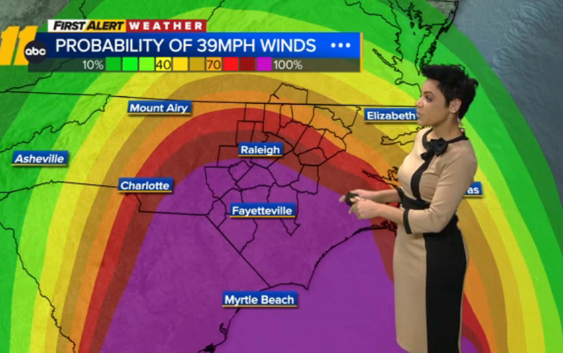
Ultimately what this means is we will likely see slightly stronger winds than we were expecting.
Ian is currently located 175 miles south-southeast of Charleston, South Carolina. The storm has sustained winds of 85 miles per hour and is moving north-northeast at 10 miles per hour.
Ian is expected to make landfall Friday between Charleston and Myrtle Beach.
However, nearly all of the storm’s rain is located north of its center. That’s why rain bands arrived in North Carolina early Friday morning — and it’s also why the majority of the rain will be over by the end of the day.
A Tropical Storm Warning remains in effect for most of central North Carolina. This means we’re going to see a lot of rain and a lot of wind.
ABC11 Meteorologist Kweilyn Murphy said most of us can expect between 2-6 inches of rain Friday. Although isolated areas will get heavier downpours which will amount to more than 6 inches. Isolated flooding will be possible in and around those areas.
In North Carolina, the strongest winds from the storm will happen closer to the South Carolina border. Those areas around the Sandhills will certainly see sustained winds near 40 miles per hour. As the storm moves north and west, it (and its winds) will weaken.
Wind gusts, which started picking up Thursday, will continue through Friday with some gusts getting up to 50 or 60 miles per hour
Big Weather’s hurricane emergency kit
North Carolina prepares for Ian
Gov. Roy Cooper declared a State of Emergency on Wednesday ahead of the arrival of the remnants of Hurricane Ian.
Cooper is scheduled to give an update on preparations at 3 p.m. ABC11 will broadcast that update live on television and in all of our apps.
North Carolina’s price gouging law against overcharging in a state of emergency is also in effect statewide.
Cooper also authorized the activation of about 80 members of the North Carolina National Guard to assist as needed.
Officials at Duke Energy said they’ve kept their North Carolina crews at home just in case we see widespread outages. They’ve spent the last couple of days making grid improvements and securing equipment, so if there is an outage, they’ll be able to respond quickly.
“We do expect to see outages. Where those are going to be were continue to monitor. But certainly it’s a real storm. People should take it seriously until it’s out of the area and we can move ahead,” said Jeff Brooks, Duke Energy.
Right now, they say they have three major concerns: wind, rain and flooding.
“This is just an all hands on deck kind of storm. It’s going to be a historic storm. The damage we’re seeing in some areas the entire grid will have to be rebuilt. Those are the kind of conditions they’re dealing with there. We’re thankful that we’re probably not going to see that here. But we could still see a lot of outages,” Brooks said.
If you do experience an outage at your home, Duke energy wants you to report it. You can text the word OUT to 57801, use the Duke energy app or call them at 800.769.3766.
Once the storm moves out of the area, Duke Energy will reevaluate and assign crews based on the hardest hit areas.
Meanwhile, home repair experts suggest homeowners take time before Ian arrives to prepare their homes and check their insurance.
WATCH: People living in Triangle flood zones ‘nervous’ about Ian
Copyright © 2022 WTVD-TV. All Rights Reserved.