- Recovery continues for western NC nearly two months after Hurricane Helene
- Recovery continues for western NC nearly three months after Hurricane Helene
- Cast of Scandal reunites to show support for western North Carolina after Hurricane Helene
- Tropical Storm Sara threatens to bring flash floods and mudslides to Central America
- Hurricane-stricken Tampa Bay Rays to play 2025 season at Yankees' spring training field in Tampa
LIVE: Severe storms bring wind, tornado threat Friday afternoon into evening

All modes of severe weather are possible.
AUSTIN, Texas — Friday is a day where we want you to be weather aware. A strong Pacific cold front sweeps into Central Texas Friday afternoon, bringing an increasing likelihood of severe storms.
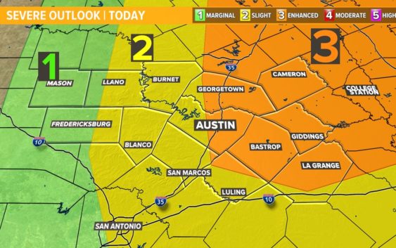
The Storm Prediction Center has now upgraded areas along and east of the Interstate 35 corridor to the “enhanced” – level 3 of 5 – risk for severe storms. The primary threats will be damaging winds and tornadoes, including the possibility of one or two significant tornadoes. Pockets of large hail will also be possible.
Make sure you have a way to get weather alerts between 4 p.m. and midnight. This is the overall severe weather window, but we have a detailed breakdown of the timeline below:
Timeline: When to expect the storms
Friday morning will begin with clouds and a few light showers or drizzle, but there is no threat of severe weather early in the day. By the early to mid afternoon, we will likely see the clouds and showers break up to reveal sunshine and temperatures in the 80s. If this happens, the stage will be set for severe storms.
Storms will develop along a cold front that moves in during the afternoon, but the crucial part of the forecast is where exactly the storms first develop. Do they develop west of I-35 and push right into the metro? Do they develop right over the I-35 corridor with a glancing blow and then move eastward? Or do they develop just east of I-35 and miss the heart of the metro all together?
These are all realistic scenarios, but right now, our most reliable computer models show storms developing by early evening along I-35, with the threat for wind, tornadoes and some pockets of hail.
The storms then push east of the I-35 corridor during the later evening hours, with the main concern perhaps shifting to damaging winds as an organized line of storms develops.
By midnight, the storms should be pushing out of Fayette and Lee counties, ending our threat for severe weather.
Cooler and drier air rushes in by Saturday morning as temperatures drop to the 40s and 50s.
Following the storms, the rest of the weekend will be pleasant and mainly dry. Temperatures are back in the 80s for most of next week with some small rain chances but no major storm threats.
Stick with the KVUE Storm Team for the latest on this developing situation.
In the meantime, the 7-Day forecast is below.
PEOPLE ARE ALSO READING: