- Artists transform hurricane aftermath into hoop-inspired masterpieces at Charlotte exhibit
- NC's cost for Hurricane Helene damage is nearly $60 billion, state says
- State to develop drone program to better respond to disasters like Helene, Florence
- South Carolina residents face deadline to get storm debris out to the curb after Hurricane Helene
- SCDOT to pick up Hurricane Helene debris for a final day in South Carolina
Forecast: Severe weather threat has ended; 40s and 50s by Saturday morning

Here are the latest updates from the KVUE Storm Team.
AUSTIN, Texas — The severe threat has been lowered in the most recent update from the Storm Prediction Center, but we still very much have the possibility of some strong to severe storms through 10 p.m. this evening. The ‘enhanced’ risk area has been pushed to the NE largely out of the KVUE area, but the ‘slight’ – level 2 of 5 – risk remains along and east of I-35.
A ‘cap’ in the atmosphere has prevented storms from forming through most of this afternoon, and there are still questions as to when exactly the ‘cap’ will break and allow storms to form. It is possible this happens directly over the I-35 corridor between 5 p.m. and 7 p.m., however, if the cap holds as the front passes through Austin, then the metro will dodge the bullet with severe storms.
So let’s be prepared for strong storms as early as 5 p.m., with storms quickly racing eastward as soon as they develop. The main threat will be gusty wind potential, but we still can’t rule out an isolated tornado or a few pockets of hail. By 10 p.m. the storms will have likely passed out of Lee and Fayette counties, and our severe weather risk will come to an end.
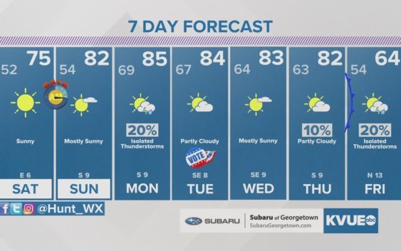
No weather worries through the rest of the weekend as cooler and drier air moves in by Saturday morning behind the front. Next week is looking relatively warm with highs in the 80s, but our next strong cold front could bring a pretty substantial cooldown by Friday and next weekend.
FRIDAY NIGHT:
60% storms prior to 10 p.m., then partly cloudy and cooler. Northwest wind at 5 to 15 mph.
LOW 52
SATURDAY:
Mainly sunny and cooler. Light northeast winds turning southeast by the afternoon.
HIGH: 75
SATURDAY NIGHT:
Mostly clear and cool. Southeast wind at 5 mph.
LOW: 54
SUNDAY:
Mainly sunny and pleasant. Light south winds at 5 to 10 mph.
HIGH: 82
SEVEN-DAY FORECAST:
Check out the live radar for what you can expect the rest of the day and into the workweek.