- Nearly every North Carolina wildfire caused by people, researchers say
- Weather IQ: How do wildfires ignite?
- EPA faces backlash for debris site near Los Angeles communities after massive wildfires
- California homeowners face potential hikes as State Farm defends wildfire rate increase
- After Hurricane Beryl, Texas lawmakers push for generators at senior living facilities
'Tornadoes our biggest threat today': Tornado watch in effect as Nicole dumps rain on NC
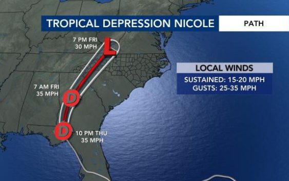
Tropical Depression Nicole on Friday will move right across North Carolina, dropping rain across the state. WRAL meteorologist Elizabeth Gardner said isolated tornadoes will be our biggest threat.

Nicole’s track has shifted west, and it will move though the N.C. mountains as a tropical depression throughout Friday. On Friday morning, Nicole’s center of circulation was near Macon, Georgia, and moving north with winds at 35 mph. A tornado watch is in effect until 3 p.m. for 31 N.C. counties and our entire area.

Tornadoes in tropical depressions are typically weak and short-lived.
Less than 2 inches of rain will fall in central N.C., and flooding and wind damage are not major concerns with this storm, Gardner said.
Heavy rain, isolated tornadoes in NC
Much of the state is under a Level 2 risk for severe weather on Friday, when heavy rain is expected in our area.

According to WRAL meteorologist Aimee Wilmoth, it won’t rain all day, we’ll see heavy bands of rain move through all the way into Friday night.
The bulk of the rain will fall in waves on Friday. Saturday will be mostly dry.
Winds will be strong, but not likely to cause significant damage in N.C., although there is a threat for some power outages and isolated tornadoes. It is likely our area could go under a tornado watch, WRAL meteorologist Elizabeth Gardner said.
This media cannot be viewed right now.
The latest models forecast wind gusts of up to 40 mph in the Triangle and up to 2 inches of rain, which is not expected to cause flooding. Wilmoth expects 1.5 inches in the Triangle.
Gusty winds, isolated tornadoes, power outages and downpours will be possible.
The Triangle area should expect to see sustained winds of 15 to 20 mph on Friday, with some gusts up to 35 to 40 mph Friday evening. Isolated and brief tornadoes are possible. Heavy rain is expected as bands move through the Triangle.
“The mountains are likely to see the heaviest rain from this system,” Gardner said, between 3 and 4 inches, and flash flooding and mudslides will be possible.
The coastal forecast is similar to central N.C., with up to 2 inches of rain and isolated tornadoes possible.
WRAL meteorologist Peta Sheerwood said models are suggesting Nicole will move out quickly and earlier on Friday, clearing by midnight.
NC preps for Nicole’s impact
More than 20 flights were canceled Thursday morning at Raleigh-Durham International Airport, most out of Orlando and Tampa. Many airports in Florida suspended flights before Nicole made landfall as a hurricane. On Friday morning, only five flights were canceled at RDU, a fairly typical number.
In the Triangle, officials are preparing for remnants of the storm to hit the Carolinas.
The Red Cross of Eastern North Carolina has volunteers and staff once again providing food, shelter and comfort for Floridians. They have sent several waves of volunteers to help with recovery, and another wave of volunteers will go this weekend for continued support.
Nicole is only the fourth hurricane ever recorded to hit the U.S. in the month of November.

Hurricane season officially extends through Nov. 30, although storms like this are more likely in September and October. Only four hurricanes have made landfall in the United States in the month of November since 1851.