- 'A little emotional': Hurricanes equipment manager got seconds in goal, memory to last a lifetime
- WMO retires three hurricane names after devastating 2024 season
- Beryl removed from future hurricane naming lists
- Hurricane names Helene, Milton and Beryl are now retired
- Hurricane Helene's name retired after deadly 2024 impact on US
HURRICANE FLORENCE: Wilmington floodwaters to crest Tuesday
Cape Fear River will be swollen through Tuesday night high tide; other rivers gradually falling
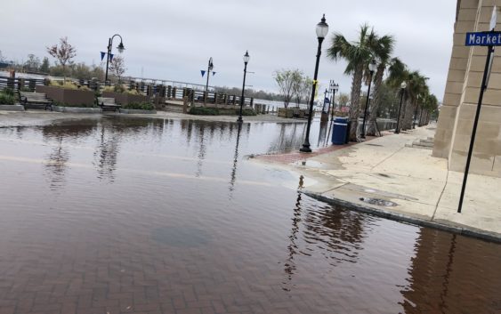
WILMINGTON — Downtown Wilmington will continue to see tidal flooding through at least Tuesday night as rains Hurricane Florence brought to central parts of North Carolina make their way to the ocean, according to the National Weather Service office in Wilmington.
“For the next couple of days, it may not drop below (flood) advisories even at low tide,” said Mark Bacon, a meteorologist at the NWS Wilmington office. “None of us ever remember that being the case.”
The Cape Fear River is expected to rise to at or near its record level of 8.2 feet, which was set in the aftermath of Hurricane Matthew two years ago, at high tide Monday evening, Tuesday morning and Tuesday night, a weather service briefing stated
“We have the highest tides occurring this evening, tomorrow morning and Tuesday evening,” Bacon said Monday morning. “That’s probably its peak.”
On Monday morning, flooding on Water Street reached its intersection with Market Street, but the road remained passable for most trucks and sport-utility vehicles, and Water Street’s east sidewalk remained walkable.
While high tides will mean higher levels, parts of downtown and at the Battleship North Carolina will still resemble a tidal pool even at low tide, the weather service said.
“It is possible that roads near the USS North Carolina and that Water Street downtown will remain flooded even at low tide tonight through Tuesday,” the briefing stated.
The storm had significant impacts throughout the region. Much of Pender County remains underwater, with officials estimating that about 3,000 buildings were flooded during the storm. Officials have had difficulty reaching many people because so many roads, including Route 53 near the Northeast Cape Fear River, were still flooded early this week.
If there is a bright spot, it’s that the Northeast Cape Fear River crested late last week, Bacon said, and is gradually getting shallower. It was still in major flood stage Monday and was expected to be at moderate flood stage through Friday while still lowering, he said.
“It’s gradual,” Bacon said of rivers moving water. “You can’t put a time or date on it.”
Bacon said rain forecast for the region this week should not exacerbate flooding because small amounts are forecast to fall.
“These slow rates and (rain) totals should have minimal impacts to river flooding,” he said.
Road conditions
Roads throughout Brunswick County also remained impassable Monday as flooding, including from the Waccamaw River, continued Monday.
The Waccamaw River “is a flat, marshy kind of river, which is why it moves slowly,” Bacon said.
And U.S. 17 from the south and north remained the only major route into and out of New Hanover County on Monday.
N.C. Department of Transportation (DOT) officials have said they will need to assess damage to Interstate 40 and U.S. 421, both of which were washed over — I-40 in parts of Pender and Duplin counties looked more like a river at the height of the storm — and make repairs before either major thoroughfare can be reopened.
Slow recovery
Some parts of the region are in recovery mode.
Debris cleanup was scheduled to begin Monday to start clearing trees, limbs and leaves from nearly every curbside in the Wilmington area.
New Hanover County’s food and water distribution centers at Castle Hayne and Veterans Park closed at noon Monday, while its downtown center at Cape Fear Community College will close Tuesday, according to county officials.
Reporter Tim Buckland can be reached at 910-343-2217 or Tim.Buckland@StarNewsOnline.com.