- Fake job seekers are flooding the market, thanks to AI
- One set of evacuation orders lifted in Caldwell County after wildfire contained
- 'We gutted every building' | Chimney Rock rebuilding after Hurricane Helene
- 'We gutted every building' | Chimney Rock rebuilding after Hurricane Helene
- Debris from Hurricane Helene provides fuel, complicates containment for spring wildfires
Beach-by-beach: How the Carolinas coast fared after Florence
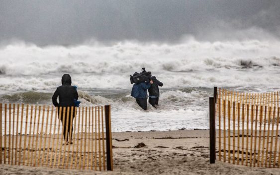
That meant water damage was the big problem at the Carolinas beaches, although winds that gusted above 100 mph blew down trees and damaged buildings in a few spots.
Life returned to normal within a few days along the northern part of the Outer Banks and south of Horry County in South Carolina, but the cleanup will take months in the hardest-hit areas.
Here is a beach-by-beach summary of Florence’s impact. Top wind gusts and rainfall totals, as measured by the National Weather Service or trained spotters, are in parentheses (where available):
North Carolina
Currituck County
(44 mph; 0.34 inches of rain) A mandatory evacuation was lifted quickly, and the public was permitted back on the beaches two days after Florence arrived at the coast. The Corolla wild horse herd suffered no ill effects, and property damage was minimal.
Dare County
Damage was light, north of Oregon Inlet. Flooding closed N.C. 12 south of there until late in the week.
Nags Head, Kitty Hawk: Minor overwash.
Kill Devil Hills: (29 mph; 0.36 inches) Some sand on N.C. 12 but no major damage.
Manteo: (49 mph; 0.79 inches) Town offices reopened four days after the storm hit.
Hatteras Island: Overwash closed N.C. 12 until late in the week, but no major structural damage.
Hyde County
(76 mph, 9.82 inches) Surge flooding and rain washed out a section of N.C. 12 on Ocracoke Island, shutting down the Hatteras Island-to-Ocracoke ferry. Two other lines opened by midweek, though. With no major damage, the island was reopened by Sept. 21.
Carteret County
Hardest-hit was Harkers Island, which remained without power for 10 days and needed shipments of food and water.
Emerald Isle: (23.49 inches) A couple sections of Bogue Inlet Pier were washed away, and flooding damaged some homes in Spinnakers Reach and Lands End. Officials, with help from the N.C. Forestry Service, spent a week pumping out water from those areas. Otherwise, light to moderate damage of buildings.
Pine Knoll Shores: (16.24 inches) The public was permitted to return by the Tuesday, Sept. 18. Light to moderate damage, mostly due to flooding.
Atlantic Beach: (112 mph, 22.16 inches) The end of Oceana Pier was destroyed, and winds blew in a wall of Crows Nest Marina. But the large U.S. flag at the town entrance survived unscathed. Considerable beach erosion.
Onslow County
North Topsail Beach: (23.4 inches) Perhaps the hardest-hit beach, with Mayor Daniel Tuman reporting 77 buildings destroyed or with major damage, and 874 with minor damage. The worst impact was north of N.C. 210. Storm surge caused overwash and damage on roads near the ocean.
Pender County
Surf City: The octagonal end of the Surf City Pier was destroyed, but the iconic tower structure survived. Fewer than 20 homes were several damaged, according to town officials, but many homes suffered some water damage.
Topsail Beach: (76 mph; 20.97 inches) Storm surge damaged several walkways on the beach and caused canals to overflow on Seventh and Ninth streets. Still, most homes and businesses suffered only siding and shingle damage.
New Hanover County
Wrightsville Beach: (86 mph; 20.11 inches) Mayor Bill Blair said there was significant street flooding during the storm. The well-known Johnnie Mercer’s Pier survived without damage. Residents were allowed back by the Tuesday, Sept. 18 and power was restored the next day. Damage was mostly to shingles and siding.
Carolina Beach: Erosion was significant, as the surge left a dropoff of 8 to 10 feet from dunes to the beach. An undetermined number of boats were damaged or destroyed by surge flooding. The U.S. Army Corps of Engineers said the beach will get a renourishment project this summer.
Kure Beach: (100 mph) Beach erosion was significant, according to the Army Corps of Engineers. The Kure Beach Pier had some railing damage. The Beachwalk area escaped major impact.
Brunswick County
Bald Head Island: (66 mph; 12.17 inches) Another hard-hit area. High water on the Cape Fear River cut off access to the island for more than 10 days. Food and water was delivered by the U.S. Coast Guard cutter Diligence. The historic boat house was destroyed. Damage to homes, due to flooding, was expected to be significant.
Caswell Beach: (62 mph; 22.57 inches) Flood and tree damage was significant. The public was allowed back on the island Monday, Sept. 24.
Southport: (27.44 inches) Downed trees and power outages shut down most businesses until the middle of the week following the storm. Flooding washed out sections of a few roads.
Oak Island: (72 mph; 26.99 inches) The island’s beaches suffered moderate erosion, but damage was not significant, according to town officials. A section of East Beach Drive was washed out. The island was reopened to the public by Wednesday, Sept. 19.
Holden Beach: Mayor Alan Holden said “damage was much less than predicted.” That included a washout on Asheboro Street and some damage to walkways and dunes at the west end. Otherwise, homes suffered siding and shingle damage.
Ocean Isle Beach: Downed trees and power lines, along with shingle and siding damage, were common across the island. But no major dune and structural damage was reported. An initial check of the sea turtle nests showed no damage.
Sunset Beach: (69 mph; 16.41 inches) Like most other Brunswick beaches, the problems were downed trees and shingle and siding damage. A few road sinkholes were reported inland. Bird Island and the iconic mailbox survived without damage.
Calabash: The town’s well-known seafood restaurants were out of action for about five days, but most were open by the Wednesday, Sept. 19 or Thursday, Sept. 20. Minor flooding was reported.
South Carolina
Horry County
The beaches got off relatively easy, but by late in the week after the storm, river flooding closed many roads throughout the county.
North Myrtle Beach: (53 mph; 11.59 inches) Some downed trees and flood streets.
Myrtle Beach: (55 mph; 9.63 inches) Businesses were closed 24-48 hours, but the city was back in operation by the Monday after the storm.
Surfside Beach, Garden City: No major damage, including to the Garden City Pier.
Georgetown County
Murrells Inlet: Goats from Goat Island were evacuated in advance, but Florence’s worst conditions stayed north of the fishing village. Some power outages, but no major problems.
Pawleys Island: (47 mph; 8.61 inches) No major damage to buildings or dunes was reported, and the island was open to the public the day after the storm moved through.
Charleston County
Mandatory evacuations were ordered, and some computer models showed Florence drifting south into the Charleston area. But the storm stayed to the north, leaving little impact on Charleston and points south.
Isle of Palms: (36 mph; 0.92 inches) Winds were offshore, so no flooding was reported.
Folly Beach, Kiawah Island, Seabrook Island: No damage reported.