- Dangerous travel conditions: Ice, snow and flooding possible
- How photos lost in disasters like Hurricane Helene find their way home, with a little help from people who care
- Dangerous travel conditions, ice/snow and flooding possible in the mountains Tuesday and Wednesday
- Weather Impact Alert: Dangerous travel conditions, ice/snow and flooding possible in the mountains Tuesday and Wednesday
- North Carolinians perplexed by unexpected DMV refunds tied to Hurricane Helene relief
Tornado Watch in effect for Mason County until 10 p.m.
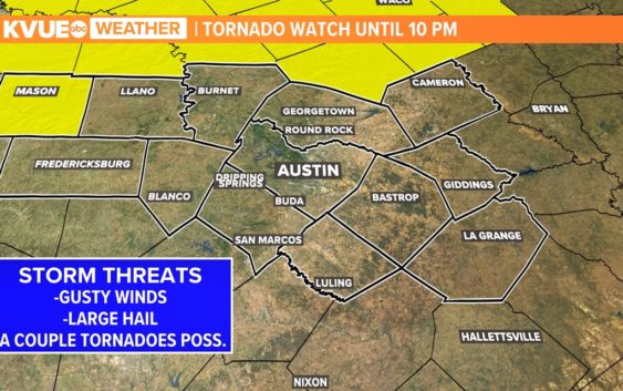
A Tornado Watch is in effect for Mason County until 10 p.m. Central Texas remains under a Heat Advisory through Friday evening.
AUSTIN, Texas — *A Tornado Watch is in effect for Mason County until 10 p.m. tonight*
While we did not have any storms materialize for Wednesday night, that does not mean that the same situation won’t play out for Thursday evening. This is because we’re once again tracking the possibility for strong to severe storms. With this in mind, let’s break down the threats associated with these storms, as well as the timing of the storms for Thursday evening.
Threats
Much of the Hill Country is in the 1 out of 5 “marginal” risk for severe weather, but sections of Llano and Burnet counties are in the “slight” – 2 out of 5 – risk for severe weather, where the storm chances are highest among the KVUE viewing area. As such, Mason County is under a tornado watch until 10 p.m. Thursday night, so please stay weather aware and prepare to take action if a tornado warning is issued.
However, those chances are not the biggest in the Plains region. Areas of Oklahoma, including areas such as Oklahoma City as well as Denison, Texas, are in a “moderate” – 4 out of 5 – risk for severe weather, with not only larger hail and more damaging winds but also stronger tornadoes with those storms.
Timing
We’re tracking mainly the early evening hours for the onset of the stronger storms in Central Texas. Around 6 p.m., we could have those storms in the Hill Country which may be strong at times.
These same storms could be along the I-35 corridor by the time we get between 8 and 9 p.m., but by that time the instability is lessened by the sunset so these will likely be your run-of-the-mill storms with frequent lightning. However, it’s important to note that a strong cap in place may prevent these storms from firing up and this is only a 10% storm chance, but it’s possible that we’ll still see a strong storm.
Excessive Heat
In addition to the storm threat for Thursday, we’re tracking some very hot temperatures for the rest of the work week into the weekend and early next week. We’ll have highs getting closer to the triple digits and eventually hotter than that for the weekend into early next week. The Heat Advisory for areas along I-35 and in the Coastal Plains has been extended to include Friday afternoon in addition to Thursday afternoon.
Drought Monitor
In addition to the excessive heat, we’ve also got an update to the drought monitor, but not much has changed, except we have seen some regression in Williamson County, as well as just north of the KVUE viewing area. Also, portions of the Coastal Plains are back in the “abnormally dry” category. It’s important to note that the National Oceanic and Atmospheric Administration (NOAA) has officially declared an El Niño, which is often associated with cooler and wetter conditions in the Lone Star State.
Stick with KVUE for the latest on all of these weather headlines.
In the meantime, your seven-day forecast is below.