- How photos lost in disasters like Hurricane Helene find their way home, with a little help from people who care
- Dangerous travel conditions, ice/snow and flooding possible in the mountains Tuesday and Wednesday
- Weather Impact Alert: Dangerous travel conditions, ice/snow and flooding possible in the mountains Tuesday and Wednesday
- North Carolinians perplexed by unexpected DMV refunds tied to Hurricane Helene relief
- Yes, NCDOT is sending Hurricane Helene relief checks
EF3 tornado latest part of memorable, active summer for weather in North Carolina
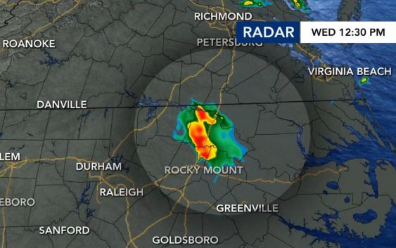
ROCKY MOUNT, N.C. — It had been 56 years since North Carolina had seen a tornado in July had wrecked the kind of havoc that we saw on Wednesday in Nash and Edgecombe counties.
The only other EF3 tornado to occur in July in North Carolina was on July 4, 1967, in Gates County, according to WRAL meteorologist Aimee Wilmoth. The National Weather Service confirmed the EF3 tornado had estimated peak winds of 150 mph and was on the ground for about 16.5 miles.
From the forecasting perspective, Wednesday’s tornado was difficult to get a read on after the weather system originated in Tennessee and didn’t appear to have to structure necessary to make it all the way into eastern North Carolina.
“Essentially, it’s an area of spin in the atmosphere that can be very sneaky and add enough turbulence to get a tornadic super cell storm,” said WRAL meteorologist Anthony Baglione. “This setup is exactly what we saw yesterday, and it looked textbook on radar. They can be very hard to forecast and pinpoint in advance.”
Veteran WRAL meteorologist Elizabeth Gardner explained some of the complexities of forecasting the tornado and how the event went from a ho-hum thunderstorm warning to a historic event.
Q: Is this one of the more surprising tornadoes you can recall forming?
A: It definitely surprised us. There have been a few that have, but it’s unusual, it’s almost unheard of. We don’t have a lot of EF3 tornadoes no matter what. The last time we had an EF3 tornado, it was in April of 2011 and we had multiple, long-track tornadoes. We had several days in advance, we knew it was coming. The day before, we had a level 5 risk for severe storms. The day before! So we knew that thing was coming. It’s highly unusual for us to have a tornado that’s this strong that pops up in a cell that’s the only thing in our entire viewing area. It was highly unusual.
Q: What made this system difficult to track?
A: This time of year, in our current pattern, we see those systems developing across the Midwest and they’re going to follow an upper level flow. And right now that’s coming out of the northwest around a ridge of high pressure. What can be difficult to predict is how long they’re going to stay together and exactly what path they’re going to take. The computer models do a pretty good job of that most of the time. But yesterday, the system was that this cluster of storms was a bit more unusual.
What happened is this one actually started in Tennessee and by the time I came into work Wednesday morning, it was moving into Charlotte and there was no good indication that it was going to hold together past Charlotte. The models were picking up on a cluster that was up in Virginia. Both of the short-range models we look at dissipated the system before it got into our area. We kept watching it, and it was dying out, but it held together just long enough to where we’re getting into 10 or 11 o’clock in the morning, getting a little daytime heating, which adds energy to the atmosphere, and then it started to build off that a little bit. When it moved past Raleigh, it moved into an area with a lot of moisture. It really strengthened when it hit that pocket of additional moisture just northeast of Raleigh.
Q: Why are tornadoes in July rare?
A: In order to have tornadoes, we need to have some cool air and some warm air. We tend to have those in the spring which makes sense because it’s been cold in the winter and now we have some warm air moving in and when you have those two air masses coming together, you have a lot of power in the atmosphere and that’s when you can have tornadoes form. Once we get past early June …
Q: Where does this fit in with some of the things we’ve seen this summer in relation to the wildfire smoke and the heavy rain coupled with the flooding?
A: This has been a very strange summer because we continue to see pockets of cool air dropping in from the north occasionally, and that’s what’s given us the potential for these stronger thunderstorms and tornadoes. We don’t have tornado signatures this time of year. But we continue to have these pockets.
It’s part of this whole pattern where we’re seeing this energy and this cooler air dropping south in a time of year we don’t normally see that. So a lot of things going on in the atmosphere.
We talk about climate change, and everybody thinks about a warming climate. The warming climate is happening. It doesn’t just mean that things are going to get hotter, it means that things are going to get hotter and then change in other ways as well. So, climate scientists would point to that flooding in New York and Vermont and something like what’s happening here this summer with this really active pattern that doesn’t normally happen in the summer, they would attribute that to climate change for sure.
The WRAL Severe Weather team is always looking for ways to best prepare viewers for ways to keep you safe and knowledgeable of your surroundings. You can download the WRAL Weather app on your mobile device for free.