- Texas’ biggest wildfire started a year ago. How does the Panhandle look now?
- To her, Hurricane Helene debris isn’t trash. It is full of memories — and she’s returning them
- Bills introduced a year after state’s largest blaze seek to limit wildfires
- A year after Texas’ largest wildfire, Panhandle residents tugged between hope and anxiety
- Another $500M for Hurricane Helene relief in North Carolina passes key hurdle
1st ever Tropical Storm Watch issued in CA as Hurricane Hilary strengthens to Category 4
SAN FRANCISCO — A newly-formed Hurricane Hilary has strengthened off Mexico’s Pacific coast, and it could bring heavy rain to the southwestern U.S. by the weekend. There will be a threat of flooding rains across Southern California from Sunday through Tuesday. The U.S. National Hurricane Center said a tropical storm watch has been issued for Southern California, the first time that has ever been done.
LIVE: Tracking Hilary’s current path as it moves toward CA
HURRICANE HILARY
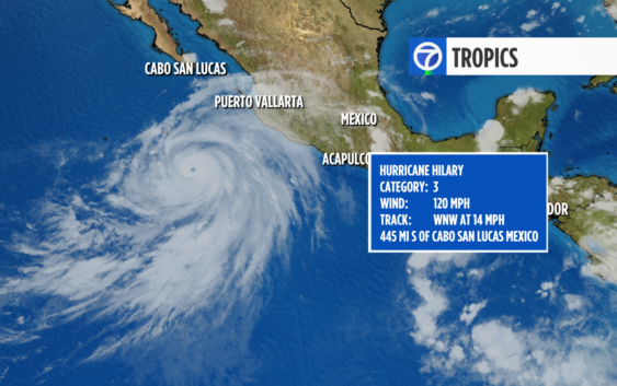
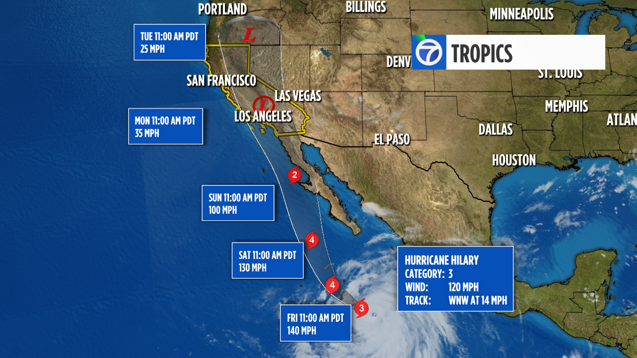
As of 11 p.m. Thursday, Hilary is a Category 4 hurricane with winds of 140 mph and is off Mexico’s Pacific coast as of Friday morning.
It is expected to further strengthen.
Then Hilary will rapidly weaken as it enters cooler ocean waters and interacts with the mountain terrain of Baja California Sunday.
The current track has Hilary moving into California on Monday as either a tropical storm or a weaker tropical depression.
It could reach Southern California as the first tropical storm there in 84 years, causing “significant and rare impacts” including extensive flooding.
RELATED: Hurricane categories explained: How strong is each category?
The U.S. National Hurricane Center said Hilary had sustained winds near 145 mph (230 kph) at 6 a.m. and was expected to continue its rapid intensification through Friday before starting to weaken.
No tropical storm has made landfall in Southern California since Sept. 25, 1939, according to the National Weather Service.
Early Friday, Hilary was centered about 400 miles (640 kilometers) south of Los Cabos on the southern tip of the Baja peninsula. It was moving west-northwest at 13 mph (20 kph), but was expected to turn gradually toward the north through Saturday.
The Mexican government extended its hurricane watch and tropical storm warning northward for parts of Baja California Sur state, and also issued a tropical storm watch for parts of mainland Mexico.
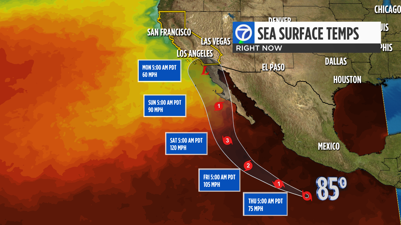
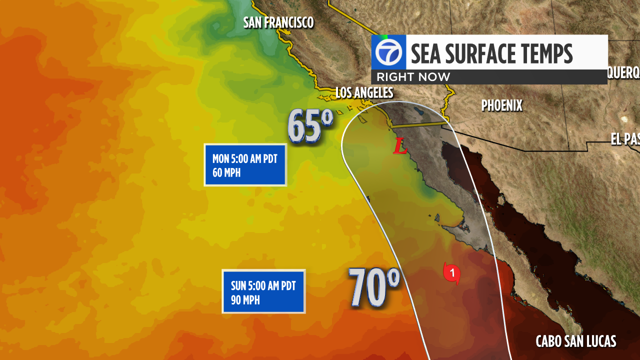
OCEAN TEMPERATURES
Hurricanes require ocean temperatures above 80 degrees to survive. Hilary is currently sitting in 85-degree water and will remain in those warm waters through Saturday. As Hilary moves closer to Baja California, ocean temperatures will quickly cool into the 70s and eventually the 60s along the California coast.
That temperature drop may not seem like a lot but ocean temperatures in the 70s will essentially kill Hilary and water in the 60s will never support a tropical system. Thus, we see a very rapid weakening as the system approaches the California-Mexico border.
INTERACTIVE: Look up how climate change is forecast to impact your neighborhood
HEAVY RAIN THREAT IN SOCAL
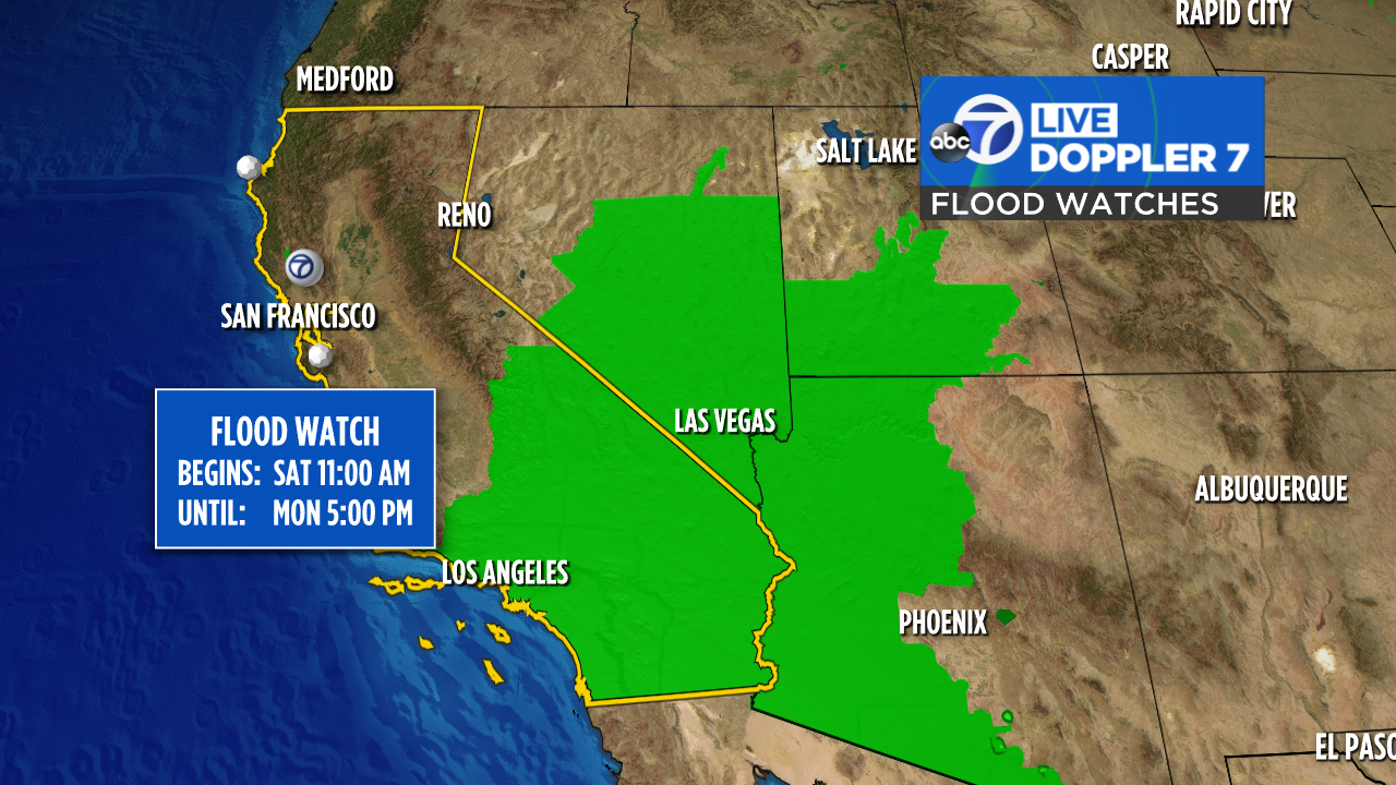
The moisture from Hilary will bring the possibility of flooding in Southern California. Flood Watches will go up this weekend.
Rough surf will also be an issue on Southern California beaches which could lead to beach erosion.
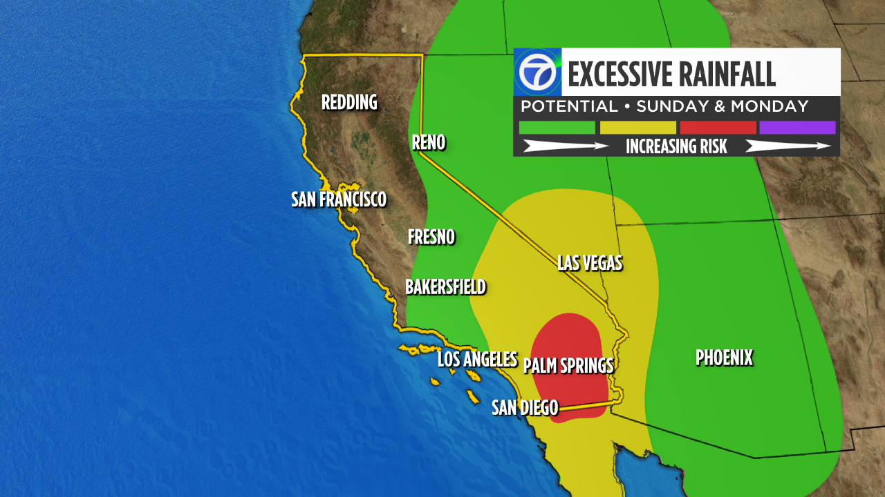
“Heavy rainfall in association with Hilary is expected to impact the Southwestern United States through next Wednesday, peaking on Sunday and Monday,” the hurricane center said. It said there was a substantial danger of flash flooding in an area stretching from San Diego to Las Vegas.
“Rainfall amounts of 3 to 6 inches, with isolated amounts of 10 inches, are expected across portions of southern California and southern Nevada, which would lead to significant and rare impacts. Elsewhere across portions of the Western United States, rainfall totals of 1 to 3 inches are expected.”
CENTRAL VALLEY IMPACTS
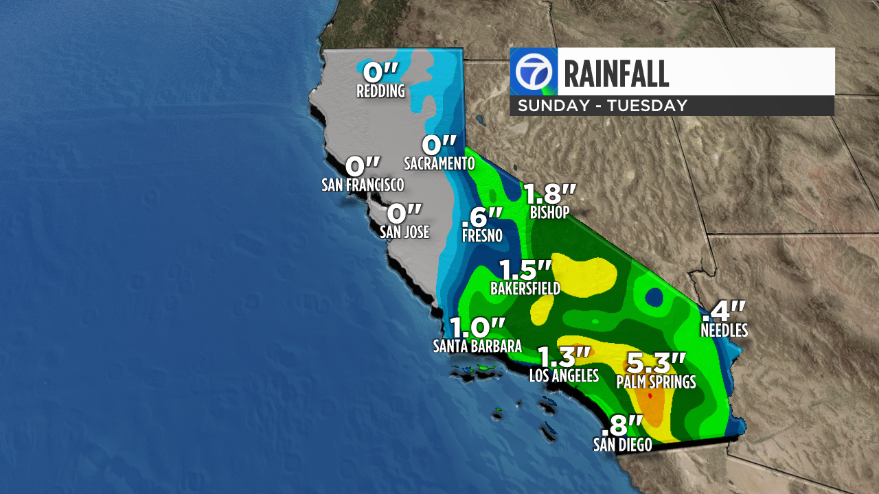
The Central Valley is forecasted to have remnants of rain and thunder from Hurricane Hilary by Monday and Tuesday.
Portions of the South Valley could first experience rainfall by Monday morning. The rest of the Central Valley will see a chance of thunderstorms by Monday afternoon.
Projected rain totals continue to change as the Valley is still a few days out from the storm, with the possibility of Hilary also downgrading.

BAY AREA IMPACTS
RELATED: Hurricane Hilary: Bay Area unlikely to see severe weather from storm as it takes aim at SoCal
The current track of Hilary keeps the bulk of the moisture in Southern California and the Sierra but, we still have a possibility of seeing a few showers Monday and Tuesday. Remnants of Hilary will bring higher humidity and tropical cloud cover between Sunday and early next week.
We will monitor the track of this storm and any small shifts would mean an increased chance of rain here. That is something we will fine-tune in the coming days.
The Associated Press contributed to this report.
Watch the latest AccuWeather forecast and take a look at recent weather stories and videos.

If you’re on the ABC7 News app, click here to watch live