- McDowell County wildfire spreads to 500 acres, evacuation orders in place
- Evacuations in Caldwell County due to wildfire
- Northwest Houston 'ghost neighborhood' caused by repeated flooding to become latest detention basin
- NHL playoffs: Hurricanes open playoffs Easter Sunday afternoon vs. Devils
- 2 wildfires spreading in rugged terrain in western North Carolina
Tracking the tropics 2023: Tropical Storm Franklin to make landfall Wednesday, increase rip currents along NC coast

Tracking the tropics 2023 | Your source for hurricane and tropical storm watch updates
Staying ahead of current tropical storms and hurricanes is crucial. Not only do you have to be prepared for any damage that might occur, but you mentally and physically need to be ready for whatever happens next. Staying ahead of the curve means knowing every upcoming storm and how it is tracking.
The WRAL Severe Weather Center is tracking the tropics to help you and your family be ready for any scenario.
Is there anything in the tropics right now?
The Atlantic has been very busy this week, with multiple tropical storms forming.
Tropical Storm Franklin
Tropical Storm Franklin is projected to make landfall Wednesday in Hispaniola.
It’s expected to intensify and become a hurricane over the weekend.
Franklin is expected to dump 5 to 10 inches of rain with isolated totals up to 15 inches and bring a storm surge of 1 to 3 feet.
The storm isn’t expected to hit the Carolinas, but the storm will create an increase in rip currents along the coast.
Tropical Storm Harold
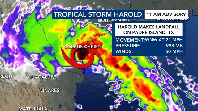
Tropical Storm Harold made landfall Tuesday around 11 a.m. on Padre Island, Texas, with winds at 50 mph. Harold is already bringing rain to Texas and could cause minor flooding.
South Texas could see as much as 4 to 6 inches of rain, said WRAL meteorologist Elizabeth Gardner, and multiple tornado warnings were in effect for the area.
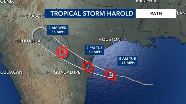
Harold’s projected path shows it moving through Texas and into Mexico before dissipating. There could be as much as 10 inches of flooding in Mexico.
Gert and Emily
Gert and Emily have dissipated and are no longer tropical storms.
Two systems with potential to develop
Meteorologists are watching two systems with potential to develop. One is off the coast of Africa and has a 60% chance of developing. The other has only a 20% chance.
The National Oceanic and Atmospheric Administration said above average temperatures in the Atlantic Ocean and the late arrival of El Nino will make for a nastier second half of hurricane season.
With the Atlantic hurricane season already well above normal so far, NOAA increased how many storms to expect and how busy the season can get. The agency said there’s a 60% chance for an above normal hurricane season — twice the agency’s May forecast, which said it was 30%.
The Atlantic hurricane season runs from June 1 to Nov. 30. The most active time is usually September through November, but it’s possible to see a hurricane make landfall any time of the year.
How to prepare for hurricane season
From late spring through the fall, there is always the chance that a hurricane will form in the Atlantic Ocean and impact North Carolina. While rough surf and overwash is a danger along the coast, hurricanes can bring torrential downpours, inland flooding, downed trees and even tornadoes to the Triangle.
It always pays to be prepared for a storm that can knock out power with a survival kit that includes non-perishable food, cash and plenty of clean, bottled water.
Worst hurricanes in North Carolina history
One of North Carolina’s most destructive hurricanes, Hurricane Fran in September 1996, blasted the Triangle with winds at near-hurricane strength. It left a landscape littered without trees in virtually every neighborhood and power outages that lasted for more than a week.
Hurricane Floyd in September 1999 inundated eastern North Carolina, including Rocky Mount, Wilson, Tarboro and Princeville, and put entire communities under water. The storm destroyed more than 8,000 homes and damaged 67,000 more.
In October 2016, Hurricane Matthew skirted the coast but generated devastating flooding across central and eastern North Carolina. The hurricane dumped more than a foot of rain 100 miles inland, swelling streams and rivers to levels above what Hurricane Floyd produced in 1999.
Hurricane Florence, in September 2018, brought a record 8.27-foot storm surge. Over the next three days, it produced up to 30 inches of rainfall over eastern North Carolina. Interstates 95 and 40 were both closed due to flooding, and 42 people died across the state.
Arguably, the most powerful hurricane in NC, Hurricane Hazel in October 1954 caused major flooding and damage as it made landfall. More than 1,000 people were killed, and it caused about $409 million in damage. The massive amount of destruction left by Hurricane Hazel earned it the nickname “the Bulldozer.”


