- Fake job seekers are flooding the market, thanks to AI
- One set of evacuation orders lifted in Caldwell County after wildfire contained
- 'We gutted every building' | Chimney Rock rebuilding after Hurricane Helene
- 'We gutted every building' | Chimney Rock rebuilding after Hurricane Helene
- Debris from Hurricane Helene provides fuel, complicates containment for spring wildfires
Weekend festivals canceled due to NC Tropical Storm Ophelia

Tropical Storm Ophelia formed on Friday and is bringing tropical storm conditions and heavy rain to North Carolina between Friday afternoon and Saturday.
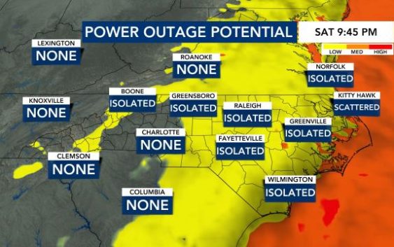
The coast will see the biggest impacts Friday night and Saturday as the storm makes landfall. Locally, we will see rain, breezy winds and some storms. Impacts in the Triangle will be isolated, but a tropical storm warning is already in effect for some counties east of Raleigh, including Edgecombe, Halifax, Nash, Sampson, Wilson and Wayne.
Timeline of impacts
Rain was already pushing into eastern North Carolina on Friday afternoon. Heavier rain and strong winds will arrive in the Triangle on Friday by 7 p.m., according to WRAL meteorologist Elizabeth Gardner.
“The bulk of the rain will arrive after 2 p.m. Friday,” said WRAL meteorologist Kat Campbell. “The heaviest rain and strongest wind will come overnight into early Saturday (8 p.m. to 11 a.m.).”
The storm could make landfall near Cape Lookout around 9 a.m. Saturday as a tropical storm. A WRAL Weather Alert Day begins Friday at 7 p.m. and lasts until 3 p.m. Saturday.
Counties east of the Triangle are under a Level 1 out of 5 risk for severe storms, and a Level 2 threat is in place at the coast. Flooding and power outages will be more likely east of the Triangle toward the coast both Friday and Saturday.
Events postponed or canceled
WRAL News is tracking a busy weekend of Triangle events, many which could be impacted by the rain.
Events happening rain or shine:
- Benson Mule Days
- Fayetteville International Folk Festival
- Party in the Peak in Apex
Events canceled:
- Morrisville International Festival
- 4th Friday’s Fiesta Latina in Fayetteville
- Emerald Isle Beach Music Festival
In eastern North Carolina, organizers of the Beaufort Pirate Invasion are closely tracking the storm.
The annual event draws up to 15,000 people for the festival and reenactments, but Beaufort is right in the path where WRAL meteorologists predict the potential tropical storm could make landfall, bringing wind gusts up to 70 mph and 5 feet of storm surge.
Organizers said they have around 100 performers camping out at the site, and they’ve already had to postpone the start of the event to Saturday.
They’re monitoring conditions now, hoping they won’t have to cancel the event entirely.
“Typically we always get a thunderstorm, and we’re always expecting possible rainstorms,” said Carl Cannon, event CEO. “But this may be our biggest storm that we’ve ever had actually hit.”
Festival organizers said there is an evacuation plan for performers at the festival site, but they are hoping the weather allows them to start the festival by Saturday afternoon.
Fayetteville preps for heavy rain
Tropical storm warnings and flood watches are in effect for some counties east of the Triangle, including Edgecombe, Halifax, Nash, Sampson, Wilson and Wayne counties, where up to 4 inches of rain will be possible. In Fayetteville and the Triangle, we’re expected to get 1 to 2 inches of rain.
WRAL Fayetteville Reporter Gilbert Baez spoke with emergency management teams in Cumberland County, who said they are monitoring the system and will make adjustments as the weather dictates.
Forecasters are not predicting any major river flooding from the potential tropical cyclone. At the Cape Fear River on Friday afternoon, the water level was nowhere near flood stage.
Gene Booth, Cumberland County’s Emergency Management Director, said flash flooding caused by heavy downpours will be the largest threat.
“The biggest concern would be your typical flash flood … low-lying areas that [experience flooding] even during a normal spring or summertime thunderstorm,” Booth said, listing areas around Ramsey Street and Martin Luther King Jr. Freeway. “Those areas typically have street-level flooding.”
Cumberland County on Friday had not planned to open any shelters or its main emergency operations center, but Booth said those resources are on standby and can become operational very quickly depending on the weather.