- CenterPoint Energy accelerates infrastructure improvements ahead of hurricane season
- Carolina Hurricanes playoff tickets go on sale Thursday
- Ask the Meteorologist: Why do tornadoes target Tornado Alley, Dixie Alley?
- Nonprofit closes distribution site that aided thousands after Hurricane Helene
- Trump approves federal assistance amid Arkansas flooding
WEATHER ALERT: Possible tornado damage in Bexar County; Flood Watch for parts of the Hill Country
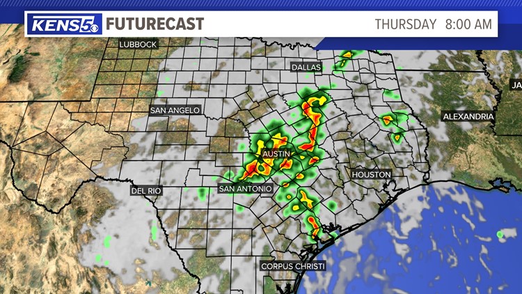
Isolated areas have received heavy rainfall. Flooding is possible in the Hill Country.
SAN ANTONIO — A Tornado Warning is in effect for portions of Comal and Hays counties until 9:45 a.m. Thursday, according to the National Weather Service. Take cover immediately if you are in these areas!
A Flash Flood Watch is in effect for Bandera, Blanco, Edwards, Burnet, Gillespie, Kendall, Kerr, Llano and Real counties through 1 p.m. Thursday afternoon.
Showers and thunderstorms are expected to continue across portions of the Hill Country through Thursday afternoon.
KENS 5 viewer Mike Scardina shared this video of a possible tornado in Seguin Thursday morning around 9 a.m.
More Videos
A moist and unstable airmass is in place and the area continues to receive remnants of a tropical cyclone help produce rainfall totals around 1 to 3 inches. Some isolated spots could receive over 4 inches overnight through Thursday.
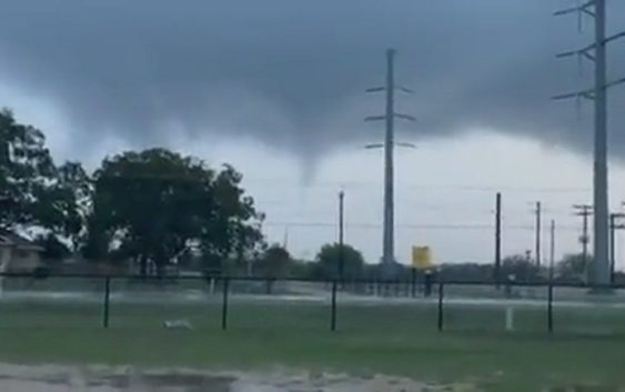
Sharon Breckenridge Thomas shared this photo of what looks like a funnel cloud, possibly a tornado, near Fort Sam Houston on Dickman Road around 8:13 a.m. Thursday morning.


For those isolated spots where heavy rainfall can occur could lead to an impact for the morning commutes in the Hill Country and along parts of the I-35 corridor.
By Thursday afternoon a drier airmass will move through the area dropping rain chances to around 20 percent. An active weather pattern continues on Friday and drops again for the weekend.