- Charlotte-based marketing agency announces $20,000 Creative Campaign Grant to help communities after Hurricane Helene
- Artists transform hurricane aftermath into hoop-inspired masterpieces at Charlotte exhibit
- NC's cost for Hurricane Helene damage is nearly $60 billion, state says
- State to develop drone program to better respond to disasters like Helene, Florence
- South Carolina residents face deadline to get storm debris out to the curb after Hurricane Helene
Saturday severe weather risk downgraded
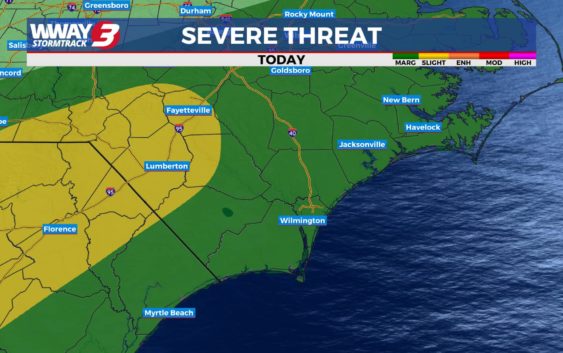
WILMINGTON, NC (WWAY)– Widespread heavy rain this morning has stabilized our atmosphere as hoped, allowing the Storm Prediction Center (SPC) to downgrade our severe weather potential from a level 2 out of 5 (slight risk) to a level 1 out of 5 (marginal risk).
Although, this afternoon and evening we are still keeping a close watch on the potential for a few stronger isolated storms to develop ahead of the cold front within this system, as that low end risk still stands.
Temperatures are trending on the cooler side so far today in the middle 60s, but breaks in cloud cover this afternoon could allow us to warm up to the middle 70s, which would help fuel some storms later on.
Our primary risk with any storms would be gusty, damaging winds.
Stay up to date on the very latest on the WWAY Daily Forecast Page.