- CenterPoint Energy accelerates infrastructure improvements ahead of hurricane season
- Carolina Hurricanes playoff tickets go on sale Thursday
- Ask the Meteorologist: Why do tornadoes target Tornado Alley, Dixie Alley?
- Nonprofit closes distribution site that aided thousands after Hurricane Helene
- Trump approves federal assistance amid Arkansas flooding
Houston severe weather updates: Downtown Houston, NRG Park now under elevated risk

Under Level 2, there is a slight risk of scattered severe storms are possible, though they’d likely be short-lived and not have widespread coverage over an area.
HOUSTON — There is a potential threat for severe weather beginning this afternoon with most of the Houston area under a Level 2 Threat Level.
Under Level 2, there is a slight risk of scattered severe storms are possible, though they’d likely be short-lived and not have widespread coverage over an area.
While they might not be as persistent, these storms could still produce isolated intense conditions.
Stay weather smart today. Get the KHOU 11 app to get alerts when severe weather watches and warnings are issued for your part of town. And we’ll be live throughout the day on KHOU 11+, which you can get for free on Roku, Fire TV and Apple TV.
There is a possibility of large hail, strong winds, and the risk of an isolated tornado.
What you need to know
- Downtown Houston and NRG Park are now under a Level 2 Threat
- Hail, strong winds, and the risk of an isolated tornado are possible
- Heavy rainfall could bring localized street flooding
- Rainfall totals of 1 to 3 inches are expected through the weekend
- The flooding threat will be greatest from Friday afternoon through late Saturday
- Rainfall should end by Sunday evening
Parts of Texas, especially in North Texas, have already experienced severe weather with large amounts of hail on Thursday evening.
Latest weather updates
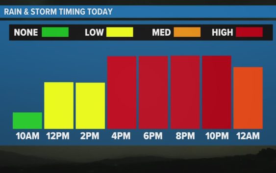
8:45 AM – Meteorologist Kim Castro provided an update on the timing of the potential severe weather as showers began developing in the area northwest and south of the Houston metro area.
8:40 AM – Meteorologist Kim Castro said the risk area for severe weather expanded this morning. Downtown Houston and NRG Park are now under a Level 2 Threat.
7:53 AM – Some storms started popping up in Waller and Cypress this morning. Be sure to stay weather smart.
7:40 AM – Meteorologist Kim Castro said there is a threat of hail, strong winds, and an isolated tornado this afternoon.
What is a tornado warning?
A Tornado Warning is issued by the local NOAA Office meteorologists who monitor the weather in the area. NOAA said they issue a warning when a tornado has been reported by spotters or indicated by radar and there is a serious threat to life and property in its path. During a tornado warning, you should act right away to find safe shelter.
What is a tornado watch?
During a Tornado Watch, tornadoes are possible in and around the watch area, according to NOAA. This means it is a good time to review your emergency plans. It is important to act quickly if a tornado warning is issued and if you spot one coming.
What to do during a tornado
If you are home, be sure to quickly go to a safe room or an interior room away from windows, which could get blown out.
If you are in a workplace or school, be sure to follow your tornado drill instructions and head to your shelter location. Again, stay away from windows. NOAA also advises against going into large open rooms like a cafeteria or gymnasium.
If you are outside, seek shelter inside a sturdy building. NOAA said to avoid sheds and storage facilities.
If you are in a vehicle, you are advised to drive to a sturdy shelter. If you are not able to get to a shelter, get down into your car or abandon it and head to a low-lying area like a ditch.
What are the signs of a tornado?
Some tornadoes form without any warning, so it is important to know what to look for. According to NOAA, these are the signs to look for:
- Strong, persistent rotation in the cloud base.
- Whirling dust or debris on the ground under a cloud base — tornadoes sometimes have no funnel!
- Hail or heavy rain followed by either dead calm or a fast, intense wind shift. Many tornadoes are wrapped in heavy precipitation and can’t be seen.
- Day or night – Loud, continuous roar or rumble, which doesn’t fade in a few seconds like thunder.
- Night – Small, bright, blue-green to white flashes at ground level near a thunderstorm (as opposed to silvery lightning up in the clouds). These mean power lines are being snapped by very strong wind, possibly a tornado.
- Night – Persistent lowering from the cloud base, illuminated or silhouetted by lightning — especially if it is visually in ground contact or there is a blue-green-white power flash underneath.
Why Harris County doesn’t have tornado sirens
Harris County is the second most tornado-prone county in the country, according to NOAA. So why don’t we have tornado sirens?
Emergency managers believe wireless alerts sent to cellphones are a better way to inform people about all kinds of hazards, including the type of tornadoes we get in Harris County.
Tornadoes in Harris County tend to be smaller and cause less damage and fewer injuries. On average, local tornadoes aren’t on the ground as long as the tornadoes seen in Dallas or Oklahoma.
Additionally, communities near chemical plants use sirens to warn of a Hazmat situation. If tornado sirens were added, emergency managers say people might be confused as to which threat is taking place.
Follow the KHOU Weather Team for live updates on the weather in your area: