- Texas’ biggest wildfire started a year ago. How does the Panhandle look now?
- To her, Hurricane Helene debris isn’t trash. It is full of memories — and she’s returning them
- Bills introduced a year after state’s largest blaze seek to limit wildfires
- A year after Texas’ largest wildfire, Panhandle residents tugged between hope and anxiety
- Another $500M for Hurricane Helene relief in North Carolina passes key hurdle
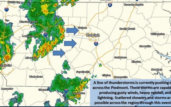
Severe storms, ‘damaging’ winds expected in NC today – ‘A tornado cannot be ruled out’
The calm skies after Florence weren’t going to last long.
Most of the Carolinas can expect severe weather today, as “lines and clusters of thunderstorms this afternoon across the foothills and Piedmont of the Carolinas and northeast Georgia,” according to the National Weather Service.
Some of those storms could organize into severe storm systems, the weather service said.
For central North Carolina east to the coast — including areas still inundated by Florence’s floodwaters — the weather service expects strong to severe thunderstorms, and a tornado is possible.
“The primary severe weather hazard will be locally damaging wind gusts. An isolated tornado cannot be ruled out, mainly along and north of Highway 64,” the weather service said.
The threat will be highest between 4 and 11 p.m., according to the weather service.
Along the coast, “rainfall amounts may be enough to result in localized flooding,” the weather service said, and “damaging wind gusts” are the “primary threat.”
For the Piedmont, western North Carolina, upstate South Carolina and northeast Georgia, the weather service said the greatest threats are damaging ground-level, straight-line winds and gusts along with “large hail.” Cloud-to-ground lighting also “will be quite frequent” in the stronger storm cells.
A flash flood watch was issued for much of western North Carolina.