- Mecklenburg County residents can attend sessions this week to apply for Hurricane Helene disaster relief
- Steiner Ranch deploys goats for wildfire prevention efforts
- Goats graze greenbelt to reduce wildfire risk in Steiner Ranch
- 'We're already strapped' | Child care crisis worsens after Hurricane Helene
- 'My heart goes out to them' | Community rallies to support Walt Disney Elementary School teachers impacted by tornado
Hurricane Beryl remains a Cat. 4 storm as it continues track to the west | TD 3 forms in Bay of Campeche
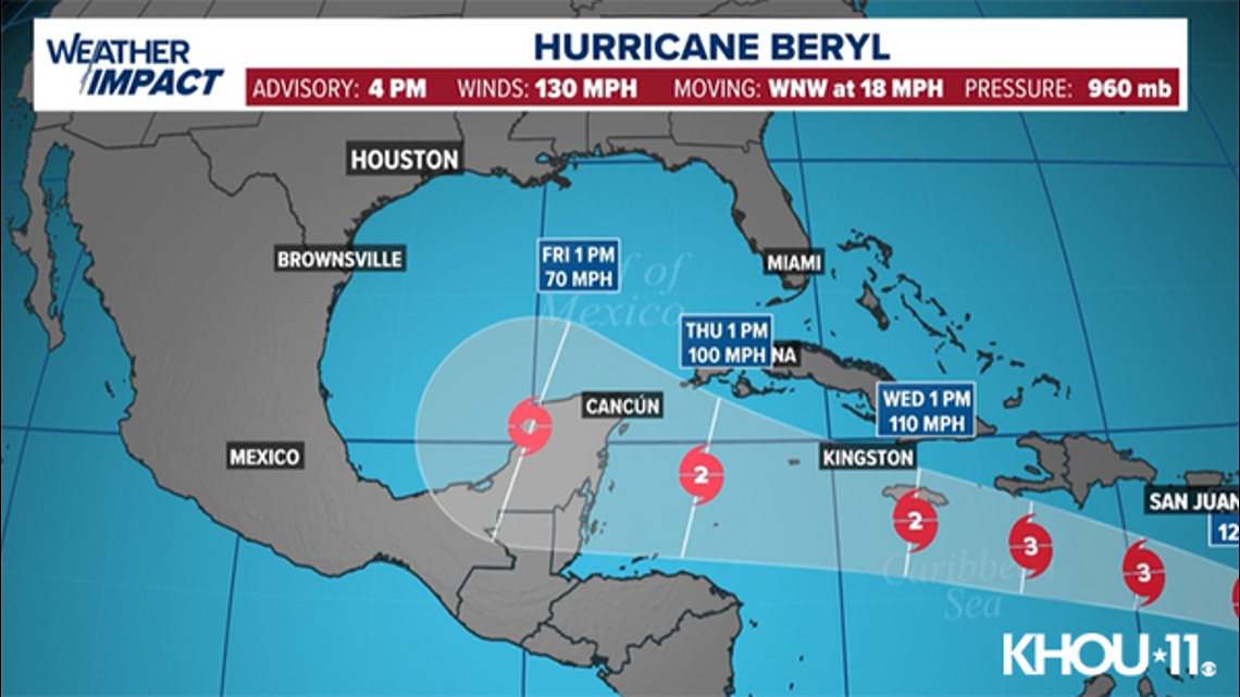
At 4 p.m., Beryl had maximum sustained winds at 130 miles per hour. It’s not moving to the west-northwest at 18 mph.
HOUSTON — Hurricane Beryl strengthened into what experts called an “extremely dangerous” Category 4 storm as it approaches the southeast Caribbean, which began shutting down Sunday amid urgent pleas from government officials for people to take shelter.
CURRENT LOCATION/PATH: With an update at 4 p.m. Sunday, Beryl was a Category 4 storm with maximum sustained winds of 130 mph, moving west-northwest at 18 mph. (Update in Spanish).
This is the earliest in a calendar year that there’s been a Cat. 4 storm in the Atlantic basin. The previous earliest was July 8, which happened in 2005.
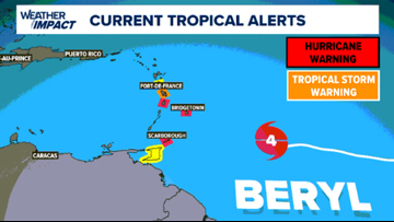
Hurricane warnings were in effect for Barbados, St. Lucia, Grenada, and St. Vincent and the Grenadines. Beryl’s center is expected to pass about 70 miles (112 kilometers) south of Barbados on Monday morning, said Sabu Best, director of Barbados’ meteorological service.
“This is a very serious situation developing for the Windward Islands,” warned the National Hurricane Center in Miami, which said that Beryl was “forecast to bring life-threatening winds and storm surge.”
Beryl is expected to pass just south of Barbados early Monday and then head into the Caribbean Sea as a major hurricane on a path toward Jamaica. It is expected to weaken by midweek, but still remain a hurricane as it heads toward Mexico.
Tropical Depression 3 forms
The third tropical depression of the Atlantic hurricane season formed in the Bay of Campeche. It’s expected to move into Mexico. It’s expected to bring flooding and possible landslides.
Watches and warnings in effect
Hurricane warnings in effect for Barbados, St. Lucia, Grenada, and St. Vincent and the Grenadines.

Beryl path

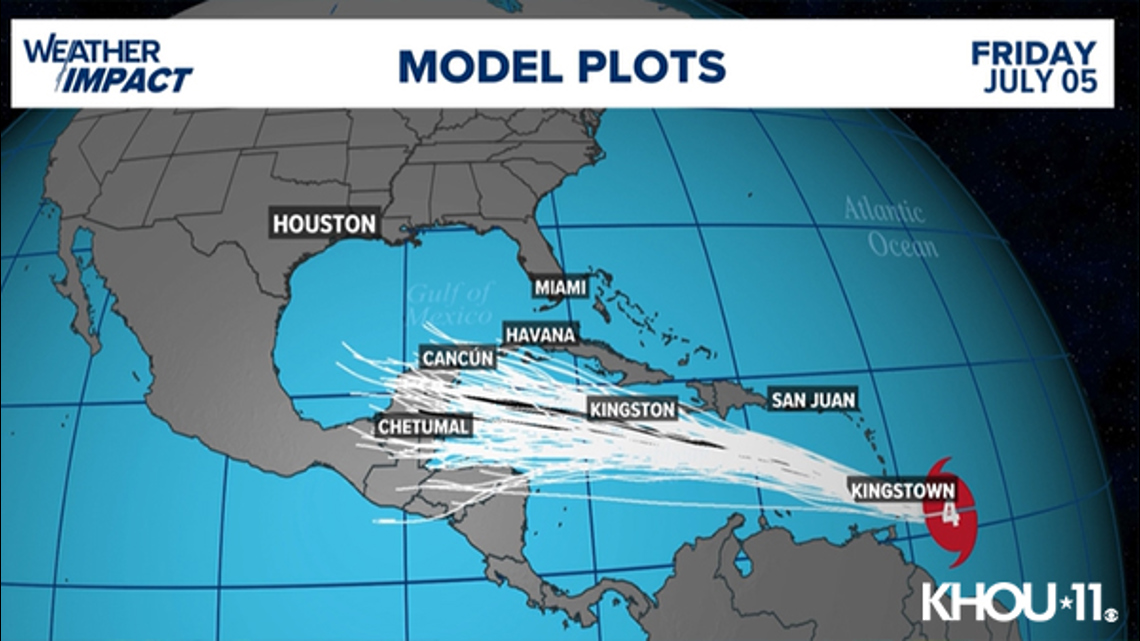
Beryl spaghetti models

Potential threats
Beryl is expected to be a major hurricane when it reaches the Windward Islands early Monday. It’s expected to bring destructive hurricane-force winds and life-threatening storm surge. Heavy rainfall and localized flooding along the Windward Islands is expected late Sunday and Monday.
Track the storm
Hurricane Season links
Hurricane season 2024 forecast
Colorado State University released its forecast update for the 2024 hurricane season, maintaining that it will be a busy one. In April, they predicted that we could see 23 named storms and 11 hurricanes with five becoming major hurricanes. They blame the extremely warm tropical Atlantic and likely “La Niña” as the primary reasons.
RELATED: Colorado State University releases hurricane season forecast update, maintains it will be a busy one
On average, the Atlantic sees about 14 named storms each hurricane season. Of those, seven become hurricanes with three becoming major (Category 3 or above) storms.
Why such an active season? Dr. Phil Klotzbach, lead forecaster at CSU, says it’s because of two main factors — above-normal sea surface temperatures and expected La Niña conditions this summer. The warm water adds more energy to the tropics, making fuel for these storms more available. But perhaps more importantly, La Niña usually reduces vertical wind shear.
Winds blowing across a developing or mature tropical system can keep a budding system from developing and weaken stronger storms. This reduces the total storm count. But when La Niña conditions are in place, this wind shear is often reduced. That, combined with the warm ocean surface temps is why Dr. Klotzbach believes more storms than normal will form.